You are here: Home > Network List > TJ - Tajikistan National Seismic Network Stations List
> Station GARM Garm, Tajikistan > Earthquake Result Viewer
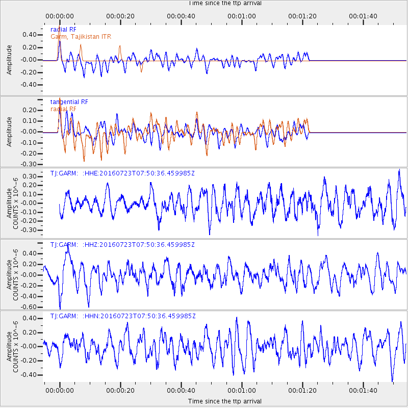
GARM Garm, Tajikistan - Earthquake Result Viewer
*The percent match for this event was below the threshold and hence no stack was calculated.
| Earthquake location: |
Southwest Of Sumatra, Indonesia |
| Earthquake latitude/longitude: |
-6.8/101.2 |
| Earthquake time(UTC): |
2016/07/23 (205) 07:41:44 GMT |
| Earthquake Depth: |
10 km |
| Earthquake Magnitude: |
5.5 MWW, 5.5 MWB, 5.5 MWC |
| Earthquake Catalog/Contributor: |
NEIC PDE/NEIC COMCAT |
|
| Network: |
TJ Tajikistan National Seismic Network |
| Station: |
GARM Garm, Tajikistan |
| Lat/Lon: |
39.00 N/70.32 E |
| Elevation: |
1305 m |
|
| Distance: |
53.8 deg |
| Az: |
330.266 deg |
| Baz: |
140.792 deg |
| Ray Param: |
$rayparam |
*The percent match for this event was below the threshold and hence was not used in the summary stack. |
|
| Radial Match: |
47.174786 % |
| Radial Bump: |
400 |
| Transverse Match: |
59.69357 % |
| Transverse Bump: |
400 |
| SOD ConfigId: |
11737051 |
| Insert Time: |
2019-04-25 03:23:55.522 +0000 |
| GWidth: |
2.5 |
| Max Bumps: |
400 |
| Tol: |
0.001 |
|
Signal To Noise
| Channel | StoN | STA | LTA |
| TJ:GARM: :HHZ:20160723T07:50:36.459985Z | 3.9844475 | 3.3990463E-7 | 8.5307846E-8 |
| TJ:GARM: :HHN:20160723T07:50:36.459985Z | 1.9106381 | 1.3473309E-7 | 7.051732E-8 |
| TJ:GARM: :HHE:20160723T07:50:36.459985Z | 1.6437755 | 1.373045E-7 | 8.352996E-8 |
| Arrivals |
| Ps | |
| PpPs | |
| PsPs/PpSs | |


