You are here: Home > Network List > GS - US Geological Survey Networks Stations List
> Station DEC08 Decatur Surface Seismic Site, Decatur, IL, USA > Earthquake Result Viewer
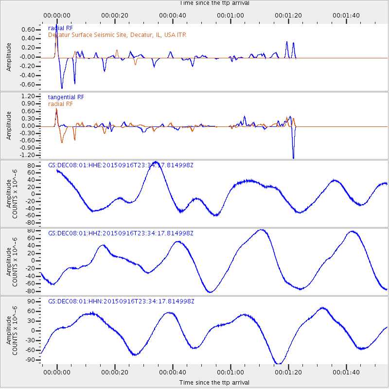
DEC08 Decatur Surface Seismic Site, Decatur, IL, USA - Earthquake Result Viewer
*The percent match for this event was below the threshold and hence no stack was calculated.
| Earthquake location: |
Near Coast Of Central Chile |
| Earthquake latitude/longitude: |
-31.2/-71.8 |
| Earthquake time(UTC): |
2015/09/16 (259) 23:23:26 GMT |
| Earthquake Depth: |
37 km |
| Earthquake Magnitude: |
5.6 MB |
| Earthquake Catalog/Contributor: |
NEIC PDE/NEIC COMCAT |
|
| Network: |
GS US Geological Survey Networks |
| Station: |
DEC08 Decatur Surface Seismic Site, Decatur, IL, USA |
| Lat/Lon: |
39.86 N/88.92 W |
| Elevation: |
210 m |
|
| Distance: |
72.4 deg |
| Az: |
346.23 deg |
| Baz: |
164.628 deg |
| Ray Param: |
$rayparam |
*The percent match for this event was below the threshold and hence was not used in the summary stack. |
|
| Radial Match: |
89.23044 % |
| Radial Bump: |
400 |
| Transverse Match: |
62.433323 % |
| Transverse Bump: |
400 |
| SOD ConfigId: |
1156111 |
| Insert Time: |
2015-10-01 00:18:33.593 +0000 |
| GWidth: |
2.5 |
| Max Bumps: |
400 |
| Tol: |
0.001 |
|
Signal To Noise
| Channel | StoN | STA | LTA |
| GS:DEC08:01:HHZ:20150916T23:34:17.814998Z | 0.9250237 | 4.5531353E-5 | 4.9221824E-5 |
| GS:DEC08:01:HHN:20150916T23:34:17.814998Z | 0.20669678 | 1.4154054E-5 | 6.847738E-5 |
| GS:DEC08:01:HHE:20150916T23:34:17.814998Z | 2.124752 | 7.380128E-5 | 3.4734065E-5 |
| Arrivals |
| Ps | |
| PpPs | |
| PsPs/PpSs | |


