You are here: Home > Network List > 7A - Mid-Atlantic Geophysical Integrative Collaboration Stations List
> Station JSPR Franklin, West Virginia USA > Earthquake Result Viewer
JSPR Franklin, West Virginia USA - Earthquake Result Viewer
| Earthquake location: |
Off Coast Of Guerrero, Mexico |
| Earthquake latitude/longitude: |
14.9/-103.5 |
| Earthquake time(UTC): |
2016/07/23 (205) 08:52:02 GMT |
| Earthquake Depth: |
45 km |
| Earthquake Magnitude: |
5.5 MB |
| Earthquake Catalog/Contributor: |
NEIC PDE/NEIC COMCAT |
|
| Network: |
7A Mid-Atlantic Geophysical Integrative Collaboration |
| Station: |
JSPR Franklin, West Virginia USA |
| Lat/Lon: |
38.64 N/79.33 W |
| Elevation: |
527 m |
|
| Distance: |
31.9 deg |
| Az: |
37.435 deg |
| Baz: |
228.638 deg |
| Ray Param: |
0.0788064 |
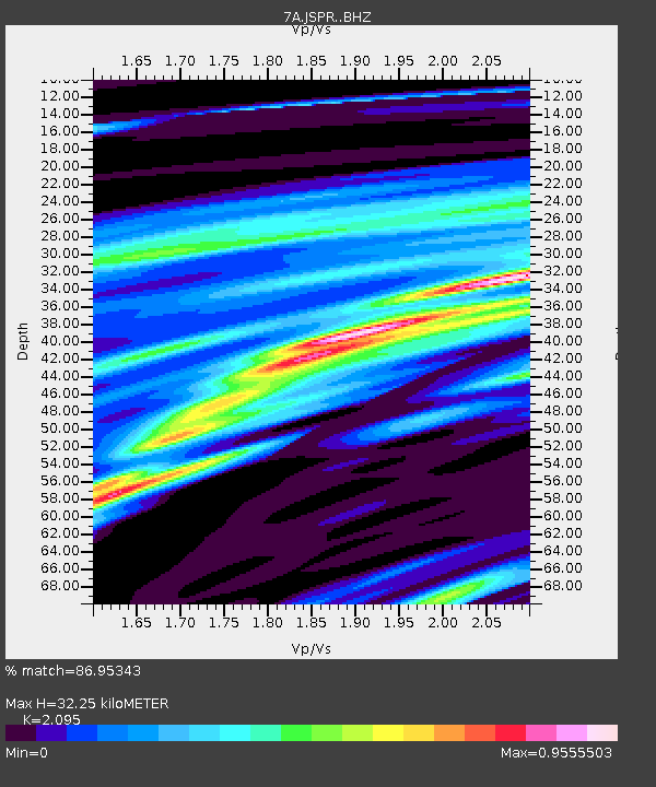
| Estimated Moho Depth: |
32.25 km |
| Estimated Crust Vp/Vs: |
2.10 |
| Assumed Crust Vp: |
6.159 km/s |
| Estimated Crust Vs: |
2.94 km/s |
| Estimated Crust Poisson's Ratio: |
0.35 |
|
| Radial Match: |
86.95343 % |
| Radial Bump: |
400 |
| Transverse Match: |
72.02619 % |
| Transverse Bump: |
400 |
| SOD ConfigId: |
11737051 |
| Insert Time: |
2019-04-25 03:24:56.777 +0000 |
| GWidth: |
2.5 |
| Max Bumps: |
400 |
| Tol: |
0.001 |
|

Signal To Noise
| Channel | StoN | STA | LTA |
| 7A:JSPR: :BHZ:20160723T08:57:53.069995Z | 8.051866 | 5.557311E-7 | 6.9018924E-8 |
| 7A:JSPR: :BHN:20160723T08:57:53.069995Z | 3.045192 | 1.5153395E-7 | 4.9761702E-8 |
| 7A:JSPR: :BHE:20160723T08:57:53.069995Z | 4.535276 | 3.1148392E-7 | 6.868025E-8 |
| Arrivals |
| Ps | 6.1 SECOND |
| PpPs | 15 SECOND |
| PsPs/PpSs | 21 SECOND |


