You are here: Home > Network List > LD - Lamont-Doherty Cooperative Seismographic Network Stations List
> Station GEDE Greenville, DE, USA > Earthquake Result Viewer
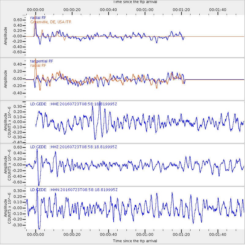
GEDE Greenville, DE, USA - Earthquake Result Viewer
*The percent match for this event was below the threshold and hence no stack was calculated.
| Earthquake location: |
Off Coast Of Guerrero, Mexico |
| Earthquake latitude/longitude: |
14.9/-103.5 |
| Earthquake time(UTC): |
2016/07/23 (205) 08:52:02 GMT |
| Earthquake Depth: |
45 km |
| Earthquake Magnitude: |
5.5 MB |
| Earthquake Catalog/Contributor: |
NEIC PDE/NEIC COMCAT |
|
| Network: |
LD Lamont-Doherty Cooperative Seismographic Network |
| Station: |
GEDE Greenville, DE, USA |
| Lat/Lon: |
39.81 N/75.64 W |
| Elevation: |
105 m |
|
| Distance: |
34.8 deg |
| Az: |
39.111 deg |
| Baz: |
232.368 deg |
| Ray Param: |
$rayparam |
*The percent match for this event was below the threshold and hence was not used in the summary stack. |
|
| Radial Match: |
67.442825 % |
| Radial Bump: |
374 |
| Transverse Match: |
58.140907 % |
| Transverse Bump: |
400 |
| SOD ConfigId: |
11737051 |
| Insert Time: |
2019-04-25 03:28:47.171 +0000 |
| GWidth: |
2.5 |
| Max Bumps: |
400 |
| Tol: |
0.001 |
|
Signal To Noise
| Channel | StoN | STA | LTA |
| LD:GEDE: :HHZ:20160723T08:58:18.819995Z | 3.7140553 | 3.347826E-7 | 9.0139366E-8 |
| LD:GEDE: :HHN:20160723T08:58:18.819995Z | 2.5576694 | 2.0337255E-7 | 7.95148E-8 |
| LD:GEDE: :HHE:20160723T08:58:18.819995Z | 1.8642657 | 1.9562017E-7 | 1.0493149E-7 |
| Arrivals |
| Ps | |
| PpPs | |
| PsPs/PpSs | |


