You are here: Home > Network List > N4 - Central and EAstern US Network Stations List
> Station J47A Sunmer, MI, USA > Earthquake Result Viewer
J47A Sunmer, MI, USA - Earthquake Result Viewer
| Earthquake location: |
Off Coast Of Guerrero, Mexico |
| Earthquake latitude/longitude: |
14.9/-103.5 |
| Earthquake time(UTC): |
2016/07/23 (205) 08:52:02 GMT |
| Earthquake Depth: |
45 km |
| Earthquake Magnitude: |
5.5 MB |
| Earthquake Catalog/Contributor: |
NEIC PDE/NEIC COMCAT |
|
| Network: |
N4 Central and EAstern US Network |
| Station: |
J47A Sunmer, MI, USA |
| Lat/Lon: |
43.24 N/84.82 W |
| Elevation: |
236 m |
|
| Distance: |
32.5 deg |
| Az: |
25.854 deg |
| Baz: |
215.241 deg |
| Ray Param: |
0.07853487 |
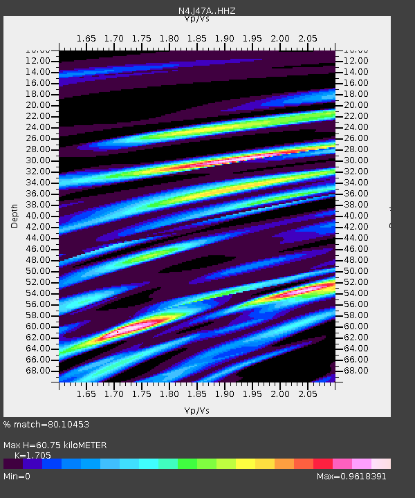
| Estimated Moho Depth: |
60.75 km |
| Estimated Crust Vp/Vs: |
1.71 |
| Assumed Crust Vp: |
6.483 km/s |
| Estimated Crust Vs: |
3.802 km/s |
| Estimated Crust Poisson's Ratio: |
0.24 |
|
| Radial Match: |
80.10453 % |
| Radial Bump: |
400 |
| Transverse Match: |
51.98184 % |
| Transverse Bump: |
400 |
| SOD ConfigId: |
11737051 |
| Insert Time: |
2019-04-25 03:29:34.861 +0000 |
| GWidth: |
2.5 |
| Max Bumps: |
400 |
| Tol: |
0.001 |
|

Signal To Noise
| Channel | StoN | STA | LTA |
| N4:J47A: :HHZ:20160723T08:57:58.640002Z | 8.999491 | 8.12737E-7 | 9.030923E-8 |
| N4:J47A: :HHN:20160723T08:57:58.640002Z | 3.0562978 | 3.6966995E-7 | 1.2095352E-7 |
| N4:J47A: :HHE:20160723T08:57:58.640002Z | 2.4770753 | 2.8066702E-7 | 1.133058E-7 |
| Arrivals |
| Ps | 7.2 SECOND |
| PpPs | 23 SECOND |
| PsPs/PpSs | 30 SECOND |


