You are here: Home > Network List > US - United States National Seismic Network Stations List
> Station ELK Elko, Nevada, USA > Earthquake Result Viewer
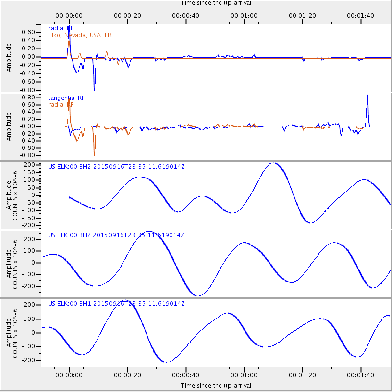
ELK Elko, Nevada, USA - Earthquake Result Viewer

| Earthquake location: |
Near Coast Of Central Chile |
| Earthquake latitude/longitude: |
-31.2/-71.8 |
| Earthquake time(UTC): |
2015/09/16 (259) 23:23:26 GMT |
| Earthquake Depth: |
37 km |
| Earthquake Magnitude: |
5.6 MB |
| Earthquake Catalog/Contributor: |
NEIC PDE/NEIC COMCAT |
|
| Network: |
US United States National Seismic Network |
| Station: |
ELK Elko, Nevada, USA |
| Lat/Lon: |
40.74 N/115.24 W |
| Elevation: |
2210 m |
|
| Distance: |
82.1 deg |
| Az: |
328.152 deg |
| Baz: |
143.464 deg |
| Ray Param: |
0.047087185 |
| Estimated Moho Depth: |
17.75 km |
| Estimated Crust Vp/Vs: |
1.60 |
| Assumed Crust Vp: |
6.276 km/s |
| Estimated Crust Vs: |
3.922 km/s |
| Estimated Crust Poisson's Ratio: |
0.18 |
|
| Radial Match: |
95.64768 % |
| Radial Bump: |
309 |
| Transverse Match: |
50.331455 % |
| Transverse Bump: |
400 |
| SOD ConfigId: |
1156111 |
| Insert Time: |
2015-10-01 00:22:12.090 +0000 |
| GWidth: |
2.5 |
| Max Bumps: |
400 |
| Tol: |
0.001 |
|
Signal To Noise
| Channel | StoN | STA | LTA |
| US:ELK:00:BHZ:20150916T23:35:11.619014Z | 2.981882 | 1.06011E-4 | 3.5551708E-5 |
| US:ELK:00:BH1:20150916T23:35:11.619014Z | 9.019154 | 1.4486746E-4 | 1.6062202E-5 |
| US:ELK:00:BH2:20150916T23:35:11.619014Z | 0.6798373 | 4.9828515E-5 | 7.329477E-5 |
| Arrivals |
| Ps | 1.7 SECOND |
| PpPs | 7.1 SECOND |
| PsPs/PpSs | 8.9 SECOND |


