You are here: Home > Network List > TA - USArray Transportable Network (new EarthScope stations) Stations List
> Station D25K Kavik River, AK, USA > Earthquake Result Viewer
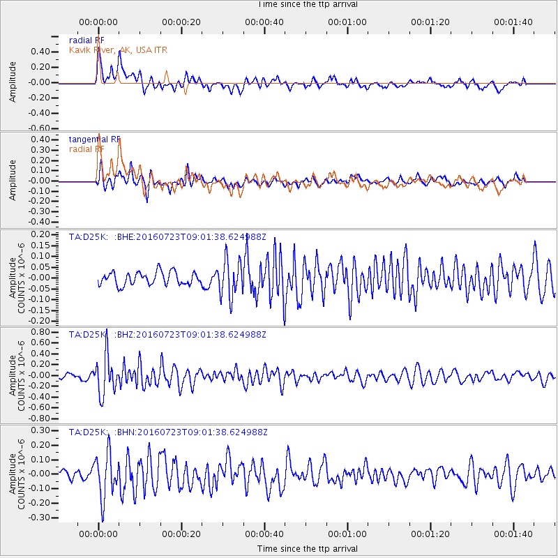
D25K Kavik River, AK, USA - Earthquake Result Viewer
*The percent match for this event was below the threshold and hence no stack was calculated.
| Earthquake location: |
Off Coast Of Guerrero, Mexico |
| Earthquake latitude/longitude: |
14.9/-103.5 |
| Earthquake time(UTC): |
2016/07/23 (205) 08:52:02 GMT |
| Earthquake Depth: |
45 km |
| Earthquake Magnitude: |
5.5 MB |
| Earthquake Catalog/Contributor: |
NEIC PDE/NEIC COMCAT |
|
| Network: |
TA USArray Transportable Network (new EarthScope stations) |
| Station: |
D25K Kavik River, AK, USA |
| Lat/Lon: |
69.32 N/146.38 W |
| Elevation: |
770 m |
|
| Distance: |
60.7 deg |
| Az: |
343.913 deg |
| Baz: |
131.031 deg |
| Ray Param: |
$rayparam |
*The percent match for this event was below the threshold and hence was not used in the summary stack. |
|
| Radial Match: |
75.01091 % |
| Radial Bump: |
400 |
| Transverse Match: |
74.62452 % |
| Transverse Bump: |
400 |
| SOD ConfigId: |
11737051 |
| Insert Time: |
2019-04-25 03:31:27.811 +0000 |
| GWidth: |
2.5 |
| Max Bumps: |
400 |
| Tol: |
0.001 |
|
Signal To Noise
| Channel | StoN | STA | LTA |
| TA:D25K: :BHZ:20160723T09:01:38.624988Z | 8.79492 | 3.6064327E-7 | 4.1005862E-8 |
| TA:D25K: :BHN:20160723T09:01:38.624988Z | 5.5482903 | 1.5438845E-7 | 2.782631E-8 |
| TA:D25K: :BHE:20160723T09:01:38.624988Z | 2.910792 | 8.6388866E-8 | 2.9678816E-8 |
| Arrivals |
| Ps | |
| PpPs | |
| PsPs/PpSs | |


