You are here: Home > Network List > US - United States National Seismic Network Stations List
> Station CBKS Cedar Bluff, Kansas, USA > Earthquake Result Viewer
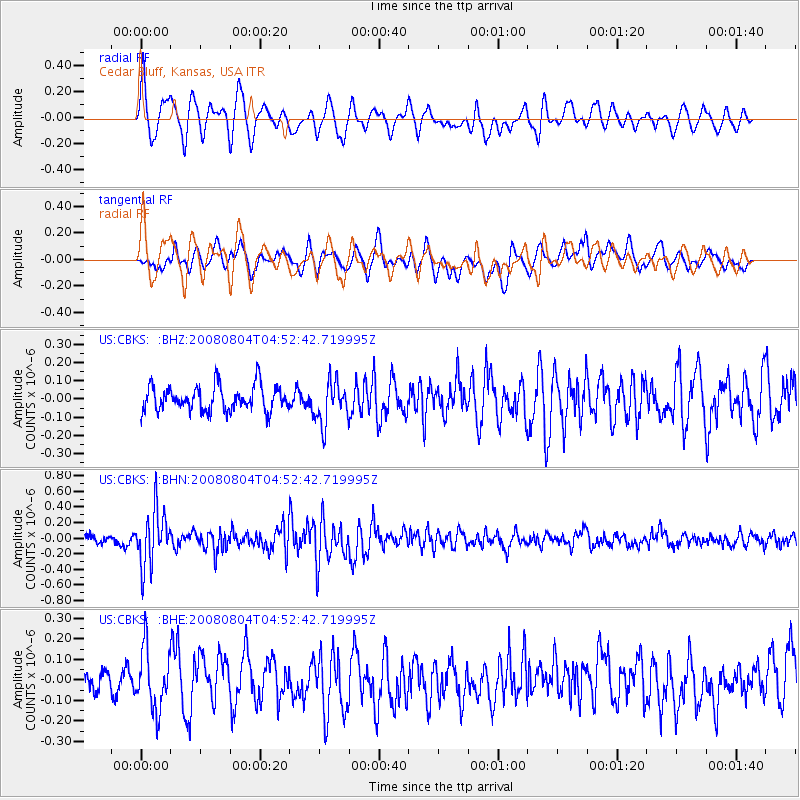
CBKS Cedar Bluff, Kansas, USA - Earthquake Result Viewer
*The percent match for this event was below the threshold and hence no stack was calculated.
| Earthquake location: |
Kuril Islands |
| Earthquake latitude/longitude: |
49.9/156.4 |
| Earthquake time(UTC): |
2008/08/04 (217) 04:42:14 GMT |
| Earthquake Depth: |
77 km |
| Earthquake Magnitude: |
5.6 MB, 5.8 MW, 5.7 MW |
| Earthquake Catalog/Contributor: |
WHDF/NEIC |
|
| Network: |
US United States National Seismic Network |
| Station: |
CBKS Cedar Bluff, Kansas, USA |
| Lat/Lon: |
38.81 N/99.74 W |
| Elevation: |
677 m |
|
| Distance: |
69.2 deg |
| Az: |
54.202 deg |
| Baz: |
317.776 deg |
| Ray Param: |
$rayparam |
*The percent match for this event was below the threshold and hence was not used in the summary stack. |
|
| Radial Match: |
74.41817 % |
| Radial Bump: |
400 |
| Transverse Match: |
49.55581 % |
| Transverse Bump: |
400 |
| SOD ConfigId: |
2504 |
| Insert Time: |
2010-03-05 05:34:19.585 +0000 |
| GWidth: |
2.5 |
| Max Bumps: |
400 |
| Tol: |
0.001 |
|
Signal To Noise
| Channel | StoN | STA | LTA |
| US:CBKS: :BHN:20080804T04:52:42.719995Z | 7.6804023 | 3.5450367E-7 | 4.6156913E-8 |
| US:CBKS: :BHE:20080804T04:52:42.719995Z | 1.9384848 | 1.463804E-7 | 7.5512794E-8 |
| US:CBKS: :BHZ:20080804T04:52:42.719995Z | 1.6770833 | 1.1556682E-7 | 6.8909415E-8 |
| Arrivals |
| Ps | |
| PpPs | |
| PsPs/PpSs | |


