You are here: Home > Network List > TA - USArray Transportable Network (new EarthScope stations) Stations List
> Station J20K Nowitna River, AK, USA > Earthquake Result Viewer
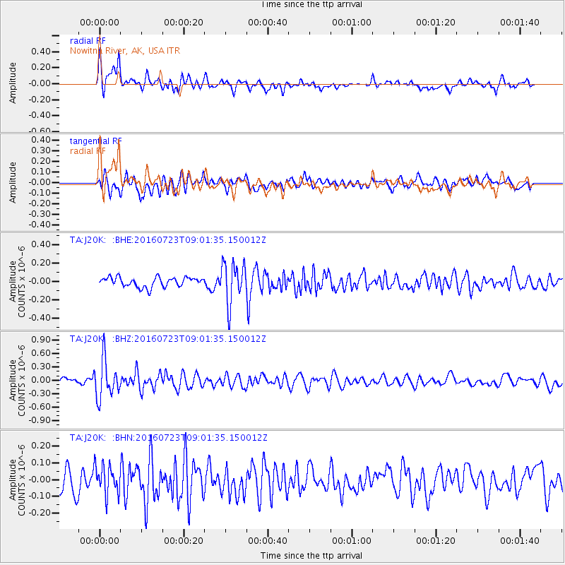
J20K Nowitna River, AK, USA - Earthquake Result Viewer
*The percent match for this event was below the threshold and hence no stack was calculated.
| Earthquake location: |
Off Coast Of Guerrero, Mexico |
| Earthquake latitude/longitude: |
14.9/-103.5 |
| Earthquake time(UTC): |
2016/07/23 (205) 08:52:02 GMT |
| Earthquake Depth: |
45 km |
| Earthquake Magnitude: |
5.5 MB |
| Earthquake Catalog/Contributor: |
NEIC PDE/NEIC COMCAT |
|
| Network: |
TA USArray Transportable Network (new EarthScope stations) |
| Station: |
J20K Nowitna River, AK, USA |
| Lat/Lon: |
64.18 N/154.15 W |
| Elevation: |
314 m |
|
| Distance: |
60.1 deg |
| Az: |
337.026 deg |
| Baz: |
120.484 deg |
| Ray Param: |
$rayparam |
*The percent match for this event was below the threshold and hence was not used in the summary stack. |
|
| Radial Match: |
75.19251 % |
| Radial Bump: |
400 |
| Transverse Match: |
58.19635 % |
| Transverse Bump: |
400 |
| SOD ConfigId: |
11737051 |
| Insert Time: |
2019-04-25 03:31:56.470 +0000 |
| GWidth: |
2.5 |
| Max Bumps: |
400 |
| Tol: |
0.001 |
|
Signal To Noise
| Channel | StoN | STA | LTA |
| TA:J20K: :BHZ:20160723T09:01:35.150012Z | 6.664492 | 4.3412788E-7 | 6.5140426E-8 |
| TA:J20K: :BHN:20160723T09:01:35.150012Z | 1.2973247 | 8.2947444E-8 | 6.393731E-8 |
| TA:J20K: :BHE:20160723T09:01:35.150012Z | 4.3299937 | 2.2588488E-7 | 5.2167486E-8 |
| Arrivals |
| Ps | |
| PpPs | |
| PsPs/PpSs | |


