You are here: Home > Network List > US - United States National Seismic Network Stations List
> Station CBKS Cedar Bluff, Kansas, USA > Earthquake Result Viewer
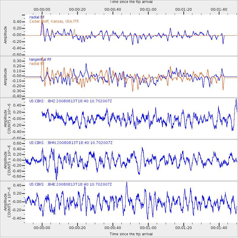
CBKS Cedar Bluff, Kansas, USA - Earthquake Result Viewer
*The percent match for this event was below the threshold and hence no stack was calculated.
| Earthquake location: |
North Of Severnaya Zemlya |
| Earthquake latitude/longitude: |
83.6/114.5 |
| Earthquake time(UTC): |
2008/08/13 (226) 18:30:57 GMT |
| Earthquake Depth: |
10 km |
| Earthquake Magnitude: |
5.7 MW, 5.2 MS, 5.3 MB, 5.7 MW |
| Earthquake Catalog/Contributor: |
WHDF/NEIC |
|
| Network: |
US United States National Seismic Network |
| Station: |
CBKS Cedar Bluff, Kansas, USA |
| Lat/Lon: |
38.81 N/99.74 W |
| Elevation: |
677 m |
|
| Distance: |
56.8 deg |
| Az: |
31.692 deg |
| Baz: |
355.639 deg |
| Ray Param: |
$rayparam |
*The percent match for this event was below the threshold and hence was not used in the summary stack. |
|
| Radial Match: |
63.153286 % |
| Radial Bump: |
400 |
| Transverse Match: |
58.720253 % |
| Transverse Bump: |
400 |
| SOD ConfigId: |
2504 |
| Insert Time: |
2010-03-05 05:34:22.361 +0000 |
| GWidth: |
2.5 |
| Max Bumps: |
400 |
| Tol: |
0.001 |
|
Signal To Noise
| Channel | StoN | STA | LTA |
| US:CBKS: :BHN:20080813T18:40:10.702007Z | 2.4713094 | 2.2762727E-7 | 9.210796E-8 |
| US:CBKS: :BHE:20080813T18:40:10.702007Z | 1.2652769 | 1.5611344E-7 | 1.2338283E-7 |
| US:CBKS: :BHZ:20080813T18:40:10.702007Z | 0.63497514 | 7.743225E-8 | 1.2194532E-7 |
| Arrivals |
| Ps | |
| PpPs | |
| PsPs/PpSs | |


