You are here: Home > Network List > UW - Pacific Northwest Regional Seismic Network Stations List
> Station LEBA Lebam, WA, USA > Earthquake Result Viewer
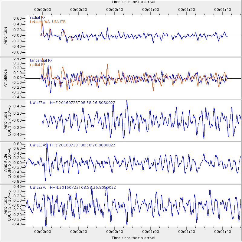
LEBA Lebam, WA, USA - Earthquake Result Viewer
*The percent match for this event was below the threshold and hence no stack was calculated.
| Earthquake location: |
Off Coast Of Guerrero, Mexico |
| Earthquake latitude/longitude: |
14.9/-103.5 |
| Earthquake time(UTC): |
2016/07/23 (205) 08:52:02 GMT |
| Earthquake Depth: |
45 km |
| Earthquake Magnitude: |
5.5 MB |
| Earthquake Catalog/Contributor: |
NEIC PDE/NEIC COMCAT |
|
| Network: |
UW Pacific Northwest Regional Seismic Network |
| Station: |
LEBA Lebam, WA, USA |
| Lat/Lon: |
46.55 N/123.56 W |
| Elevation: |
73 m |
|
| Distance: |
35.8 deg |
| Az: |
336.137 deg |
| Baz: |
145.474 deg |
| Ray Param: |
$rayparam |
*The percent match for this event was below the threshold and hence was not used in the summary stack. |
|
| Radial Match: |
58.45952 % |
| Radial Bump: |
400 |
| Transverse Match: |
59.93915 % |
| Transverse Bump: |
400 |
| SOD ConfigId: |
11737051 |
| Insert Time: |
2019-04-25 03:33:00.416 +0000 |
| GWidth: |
2.5 |
| Max Bumps: |
400 |
| Tol: |
0.001 |
|
Signal To Noise
| Channel | StoN | STA | LTA |
| UW:LEBA: :HHZ:20160723T08:58:26.808002Z | 3.978073 | 4.0558575E-7 | 1.0195534E-7 |
| UW:LEBA: :HHN:20160723T08:58:26.808002Z | 2.1725397 | 2.0152477E-7 | 9.276E-8 |
| UW:LEBA: :HHE:20160723T08:58:26.808002Z | 1.0204881 | 1.4924485E-7 | 1.462485E-7 |
| Arrivals |
| Ps | |
| PpPs | |
| PsPs/PpSs | |


