You are here: Home > Network List > UU - University of Utah Regional Network Stations List
> Station LIUT Lila Canyon, UT, USA > Earthquake Result Viewer
LIUT Lila Canyon, UT, USA - Earthquake Result Viewer
| Earthquake location: |
Near Coast Of Central Chile |
| Earthquake latitude/longitude: |
-31.2/-71.8 |
| Earthquake time(UTC): |
2015/09/16 (259) 23:23:26 GMT |
| Earthquake Depth: |
37 km |
| Earthquake Magnitude: |
5.6 MB |
| Earthquake Catalog/Contributor: |
NEIC PDE/NEIC COMCAT |
|
| Network: |
UU University of Utah Regional Network |
| Station: |
LIUT Lila Canyon, UT, USA |
| Lat/Lon: |
39.42 N/110.33 W |
| Elevation: |
2178 m |
|
| Distance: |
78.8 deg |
| Az: |
330.529 deg |
| Baz: |
147.011 deg |
| Ray Param: |
0.04931428 |
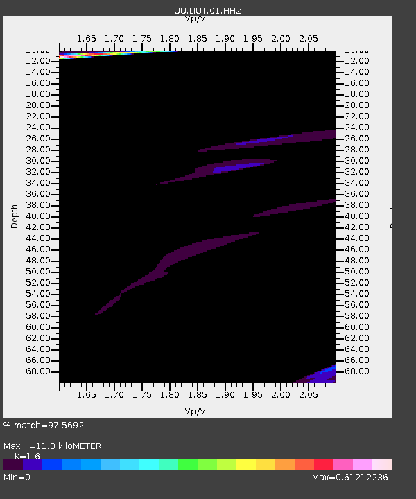
| Estimated Moho Depth: |
11.0 km |
| Estimated Crust Vp/Vs: |
1.60 |
| Assumed Crust Vp: |
6.207 km/s |
| Estimated Crust Vs: |
3.879 km/s |
| Estimated Crust Poisson's Ratio: |
0.18 |
|
| Radial Match: |
97.5692 % |
| Radial Bump: |
314 |
| Transverse Match: |
73.1821 % |
| Transverse Bump: |
297 |
| SOD ConfigId: |
1156111 |
| Insert Time: |
2015-10-01 00:23:52.997 +0000 |
| GWidth: |
2.5 |
| Max Bumps: |
400 |
| Tol: |
0.001 |
|

Signal To Noise
| Channel | StoN | STA | LTA |
| UU:LIUT:01:HHZ:20150916T23:34:54.330012Z | 0.8451539 | 9.1399943E-7 | 1.0814591E-6 |
| UU:LIUT:01:HHN:20150916T23:34:54.330012Z | 1.2768899 | 1.8921422E-6 | 1.4818365E-6 |
| UU:LIUT:01:HHE:20150916T23:34:54.330012Z | 2.6220198 | 1.9849774E-6 | 7.5704133E-7 |
| Arrivals |
| Ps | 1.1 SECOND |
| PpPs | 4.5 SECOND |
| PsPs/PpSs | 5.6 SECOND |


