You are here: Home > Network List > US - United States National Seismic Network Stations List
> Station CBKS Cedar Bluff, Kansas, USA > Earthquake Result Viewer
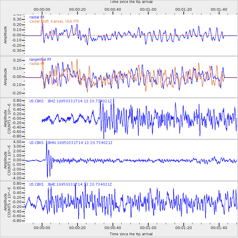
CBKS Cedar Bluff, Kansas, USA - Earthquake Result Viewer
*The percent match for this event was below the threshold and hence no stack was calculated.
| Earthquake location: |
Sea Of Japan |
| Earthquake latitude/longitude: |
38.2/135.1 |
| Earthquake time(UTC): |
1995/03/31 (090) 14:01:40 GMT |
| Earthquake Depth: |
365 km |
| Earthquake Magnitude: |
6.0 MB, 6.2 UNKNOWN, 6.3 MW |
| Earthquake Catalog/Contributor: |
WHDF/NEIC |
|
| Network: |
US United States National Seismic Network |
| Station: |
CBKS Cedar Bluff, Kansas, USA |
| Lat/Lon: |
38.81 N/99.74 W |
| Elevation: |
677 m |
|
| Distance: |
88.3 deg |
| Az: |
39.688 deg |
| Baz: |
319.874 deg |
| Ray Param: |
$rayparam |
*The percent match for this event was below the threshold and hence was not used in the summary stack. |
|
| Radial Match: |
58.174026 % |
| Radial Bump: |
400 |
| Transverse Match: |
54.841766 % |
| Transverse Bump: |
400 |
| SOD ConfigId: |
4480 |
| Insert Time: |
2010-03-05 05:34:35.380 +0000 |
| GWidth: |
2.5 |
| Max Bumps: |
400 |
| Tol: |
0.001 |
|
Signal To Noise
| Channel | StoN | STA | LTA |
| US:CBKS: :BHN:19950331T14:13:20.734021Z | 22.214294 | 1.5808121E-6 | 7.1161935E-8 |
| US:CBKS: :BHE:19950331T14:13:20.734021Z | 2.215764 | 2.4630626E-7 | 1.1116087E-7 |
| US:CBKS: :BHZ:19950331T14:13:20.734021Z | 3.2323024 | 3.359382E-7 | 1.0393156E-7 |
| Arrivals |
| Ps | |
| PpPs | |
| PsPs/PpSs | |


