You are here: Home > Network List > US - United States National Seismic Network Stations List
> Station CBKS Cedar Bluff, Kansas, USA > Earthquake Result Viewer
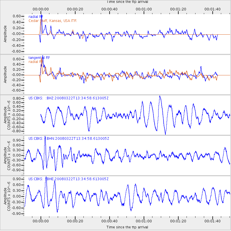
CBKS Cedar Bluff, Kansas, USA - Earthquake Result Viewer
*The percent match for this event was below the threshold and hence no stack was calculated.
| Earthquake location: |
West Chile Rise |
| Earthquake latitude/longitude: |
-44.1/-82.0 |
| Earthquake time(UTC): |
2008/03/22 (082) 13:22:59 GMT |
| Earthquake Depth: |
10 km |
| Earthquake Magnitude: |
5.6 MB, 5.1 MS, 5.4 MW |
| Earthquake Catalog/Contributor: |
WHDF/NEIC |
|
| Network: |
US United States National Seismic Network |
| Station: |
CBKS Cedar Bluff, Kansas, USA |
| Lat/Lon: |
38.81 N/99.74 W |
| Elevation: |
677 m |
|
| Distance: |
84.0 deg |
| Az: |
346.145 deg |
| Baz: |
167.232 deg |
| Ray Param: |
$rayparam |
*The percent match for this event was below the threshold and hence was not used in the summary stack. |
|
| Radial Match: |
52.18345 % |
| Radial Bump: |
400 |
| Transverse Match: |
72.82896 % |
| Transverse Bump: |
400 |
| SOD ConfigId: |
2504 |
| Insert Time: |
2010-03-05 05:34:37.434 +0000 |
| GWidth: |
2.5 |
| Max Bumps: |
400 |
| Tol: |
0.001 |
|
Signal To Noise
| Channel | StoN | STA | LTA |
| US:CBKS: :BHN:20080322T13:34:58.613005Z | 2.5058162 | 5.0202783E-7 | 2.0034503E-7 |
| US:CBKS: :BHE:20080322T13:34:58.613005Z | 1.9090348 | 4.8305236E-7 | 2.5303487E-7 |
| US:CBKS: :BHZ:20080322T13:34:58.613005Z | 1.1142999 | 2.7889863E-7 | 2.5029044E-7 |
| Arrivals |
| Ps | |
| PpPs | |
| PsPs/PpSs | |


