You are here: Home > Network List > US - United States National Seismic Network Stations List
> Station PKME Peaks-Kenny State Park, Maine, USA > Earthquake Result Viewer
PKME Peaks-Kenny State Park, Maine, USA - Earthquake Result Viewer
| Earthquake location: |
Gulf Of California |
| Earthquake latitude/longitude: |
29.6/-113.8 |
| Earthquake time(UTC): |
2009/08/05 (217) 09:13:12 GMT |
| Earthquake Depth: |
10 km |
| Earthquake Magnitude: |
5.5 MB, 5.6 MS, 5.7 MW |
| Earthquake Catalog/Contributor: |
WHDF/NEIC |
|
| Network: |
US United States National Seismic Network |
| Station: |
PKME Peaks-Kenny State Park, Maine, USA |
| Lat/Lon: |
45.26 N/69.29 W |
| Elevation: |
108 m |
|
| Distance: |
38.1 deg |
| Az: |
53.307 deg |
| Baz: |
261.379 deg |
| Ray Param: |
0.07574657 |
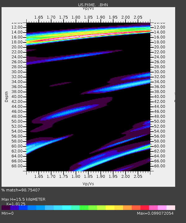
| Estimated Moho Depth: |
15.5 km |
| Estimated Crust Vp/Vs: |
1.81 |
| Assumed Crust Vp: |
6.419 km/s |
| Estimated Crust Vs: |
3.542 km/s |
| Estimated Crust Poisson's Ratio: |
0.28 |
|
| Radial Match: |
98.75407 % |
| Radial Bump: |
113 |
| Transverse Match: |
49.667557 % |
| Transverse Bump: |
400 |
| SOD ConfigId: |
2622 |
| Insert Time: |
2010-03-05 05:35:32.589 +0000 |
| GWidth: |
2.5 |
| Max Bumps: |
400 |
| Tol: |
0.001 |
|
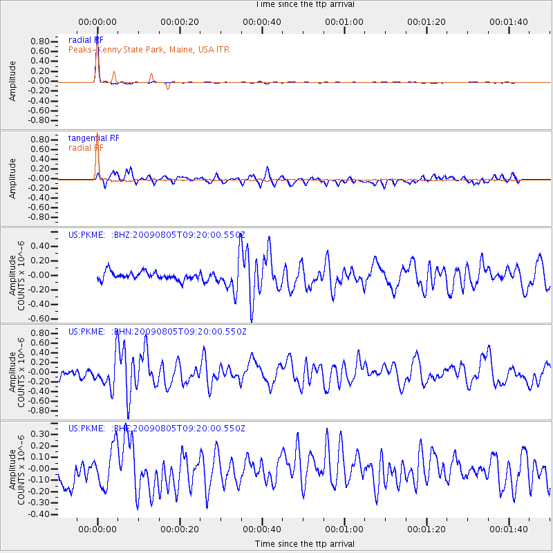
Signal To Noise
| Channel | StoN | STA | LTA |
| US:PKME: :BHN:20090805T09:20:00.550Z | 4.5140514 | 3.2702292E-7 | 7.2445545E-8 |
| US:PKME: :BHE:20090805T09:20:00.550Z | 1.3680743 | 1.7978257E-7 | 1.3141288E-7 |
| US:PKME: :BHZ:20090805T09:20:00.550Z | 4.222129 | 2.2682596E-7 | 5.3723127E-8 |
| Arrivals |
| Ps | 2.1 SECOND |
| PpPs | 6.3 SECOND |
| PsPs/PpSs | 8.4 SECOND |


