You are here: Home > Network List > N4 - Central and EAstern US Network Stations List
> Station N33B J Bar K, Exeter, NE, USA > Earthquake Result Viewer
N33B J Bar K, Exeter, NE, USA - Earthquake Result Viewer
| Earthquake location: |
Alaska Peninsula |
| Earthquake latitude/longitude: |
58.6/-156.6 |
| Earthquake time(UTC): |
2016/07/23 (205) 09:59:00 GMT |
| Earthquake Depth: |
204 km |
| Earthquake Magnitude: |
5.7 MB, 5.1 MI, 5.4 ML |
| Earthquake Catalog/Contributor: |
NEIC PDE/NEIC COMCAT |
|
| Network: |
N4 Central and EAstern US Network |
| Station: |
N33B J Bar K, Exeter, NE, USA |
| Lat/Lon: |
40.74 N/97.45 W |
| Elevation: |
482 m |
|
| Distance: |
40.7 deg |
| Az: |
89.252 deg |
| Baz: |
316.388 deg |
| Ray Param: |
0.07343184 |
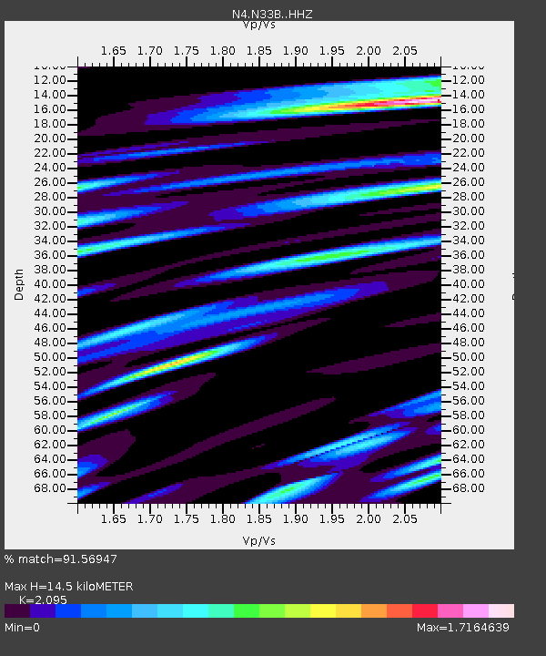
| Estimated Moho Depth: |
14.5 km |
| Estimated Crust Vp/Vs: |
2.10 |
| Assumed Crust Vp: |
6.498 km/s |
| Estimated Crust Vs: |
3.101 km/s |
| Estimated Crust Poisson's Ratio: |
0.35 |
|
| Radial Match: |
91.56947 % |
| Radial Bump: |
348 |
| Transverse Match: |
78.29383 % |
| Transverse Bump: |
400 |
| SOD ConfigId: |
11737051 |
| Insert Time: |
2019-04-25 03:41:34.978 +0000 |
| GWidth: |
2.5 |
| Max Bumps: |
400 |
| Tol: |
0.001 |
|

Signal To Noise
| Channel | StoN | STA | LTA |
| N4:N33B: :HHZ:20160723T10:05:50.649994Z | 18.676779 | 1.8060622E-6 | 9.6700944E-8 |
| N4:N33B: :HHN:20160723T10:05:50.649994Z | 10.241285 | 1.0213214E-6 | 9.97259E-8 |
| N4:N33B: :HHE:20160723T10:05:50.649994Z | 8.186174 | 7.5127116E-7 | 9.177317E-8 |
| Arrivals |
| Ps | 2.6 SECOND |
| PpPs | 6.5 SECOND |
| PsPs/PpSs | 9.1 SECOND |


