You are here: Home > Network List > N4 - Central and EAstern US Network Stations List
> Station R32B Long Quarter, Great Bend, KS, USA > Earthquake Result Viewer
R32B Long Quarter, Great Bend, KS, USA - Earthquake Result Viewer
| Earthquake location: |
Alaska Peninsula |
| Earthquake latitude/longitude: |
58.6/-156.6 |
| Earthquake time(UTC): |
2016/07/23 (205) 09:59:00 GMT |
| Earthquake Depth: |
204 km |
| Earthquake Magnitude: |
5.7 MB, 5.1 MI, 5.4 ML |
| Earthquake Catalog/Contributor: |
NEIC PDE/NEIC COMCAT |
|
| Network: |
N4 Central and EAstern US Network |
| Station: |
R32B Long Quarter, Great Bend, KS, USA |
| Lat/Lon: |
38.42 N/98.71 W |
| Elevation: |
568 m |
|
| Distance: |
41.7 deg |
| Az: |
92.718 deg |
| Baz: |
318.195 deg |
| Ray Param: |
0.07281646 |
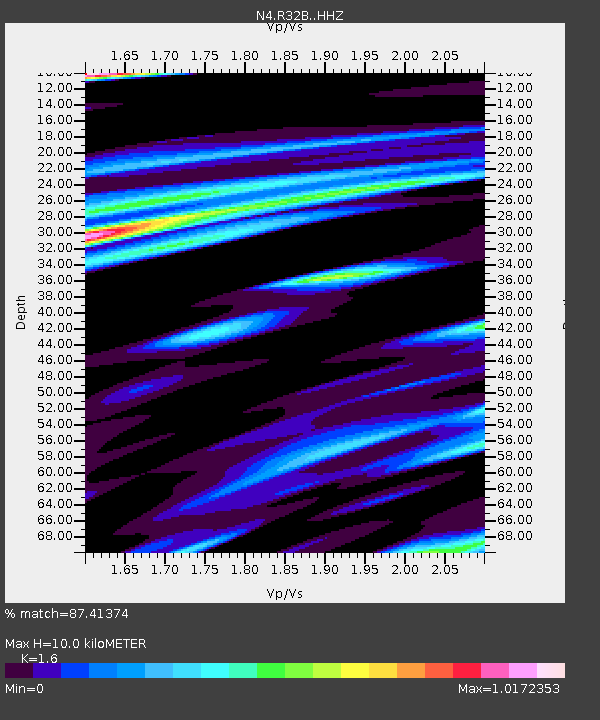
| Estimated Moho Depth: |
10.0 km |
| Estimated Crust Vp/Vs: |
1.60 |
| Assumed Crust Vp: |
6.483 km/s |
| Estimated Crust Vs: |
4.052 km/s |
| Estimated Crust Poisson's Ratio: |
0.18 |
|
| Radial Match: |
87.41374 % |
| Radial Bump: |
400 |
| Transverse Match: |
66.44927 % |
| Transverse Bump: |
400 |
| SOD ConfigId: |
11737051 |
| Insert Time: |
2019-04-25 03:41:56.931 +0000 |
| GWidth: |
2.5 |
| Max Bumps: |
400 |
| Tol: |
0.001 |
|

Signal To Noise
| Channel | StoN | STA | LTA |
| N4:R32B: :HHZ:20160723T10:05:59.049988Z | 13.362261 | 8.944226E-7 | 6.693647E-8 |
| N4:R32B: :HHN:20160723T10:05:59.049988Z | 4.625248 | 2.894248E-7 | 6.257498E-8 |
| N4:R32B: :HHE:20160723T10:05:59.049988Z | 5.028682 | 3.0681326E-7 | 6.1012656E-8 |
| Arrivals |
| Ps | 1.0 SECOND |
| PpPs | 3.7 SECOND |
| PsPs/PpSs | 4.7 SECOND |


