You are here: Home > Network List > N4 - Central and EAstern US Network Stations List
> Station U38B Mount Pleasant Farm, Gravette, AR, USA > Earthquake Result Viewer
U38B Mount Pleasant Farm, Gravette, AR, USA - Earthquake Result Viewer
| Earthquake location: |
Alaska Peninsula |
| Earthquake latitude/longitude: |
58.6/-156.6 |
| Earthquake time(UTC): |
2016/07/23 (205) 09:59:00 GMT |
| Earthquake Depth: |
204 km |
| Earthquake Magnitude: |
5.7 MB, 5.1 MI, 5.4 ML |
| Earthquake Catalog/Contributor: |
NEIC PDE/NEIC COMCAT |
|
| Network: |
N4 Central and EAstern US Network |
| Station: |
U38B Mount Pleasant Farm, Gravette, AR, USA |
| Lat/Lon: |
36.44 N/94.39 W |
| Elevation: |
389 m |
|
| Distance: |
45.5 deg |
| Az: |
90.849 deg |
| Baz: |
319.461 deg |
| Ray Param: |
0.07046839 |
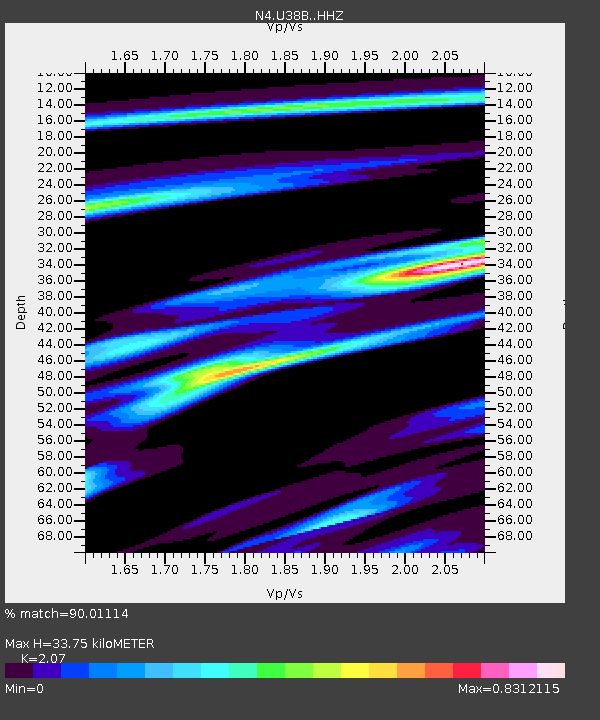
| Estimated Moho Depth: |
33.75 km |
| Estimated Crust Vp/Vs: |
2.07 |
| Assumed Crust Vp: |
6.53 km/s |
| Estimated Crust Vs: |
3.155 km/s |
| Estimated Crust Poisson's Ratio: |
0.35 |
|
| Radial Match: |
90.01114 % |
| Radial Bump: |
304 |
| Transverse Match: |
66.60602 % |
| Transverse Bump: |
400 |
| SOD ConfigId: |
11737051 |
| Insert Time: |
2019-04-25 03:42:12.657 +0000 |
| GWidth: |
2.5 |
| Max Bumps: |
400 |
| Tol: |
0.001 |
|

Signal To Noise
| Channel | StoN | STA | LTA |
| N4:U38B: :HHZ:20160723T10:06:28.959991Z | 14.130327 | 7.291667E-7 | 5.1602957E-8 |
| N4:U38B: :HHN:20160723T10:06:28.959991Z | 6.9557343 | 2.8993085E-7 | 4.168228E-8 |
| N4:U38B: :HHE:20160723T10:06:28.959991Z | 5.034472 | 1.9749689E-7 | 3.922892E-8 |
| Arrivals |
| Ps | 5.8 SECOND |
| PpPs | 15 SECOND |
| PsPs/PpSs | 21 SECOND |


