You are here: Home > Network List > N4 - Central and EAstern US Network Stations List
> Station Y52A Lilburn, GA, USA > Earthquake Result Viewer
Y52A Lilburn, GA, USA - Earthquake Result Viewer
| Earthquake location: |
Alaska Peninsula |
| Earthquake latitude/longitude: |
58.6/-156.6 |
| Earthquake time(UTC): |
2016/07/23 (205) 09:59:00 GMT |
| Earthquake Depth: |
204 km |
| Earthquake Magnitude: |
5.7 MB, 5.1 MI, 5.4 ML |
| Earthquake Catalog/Contributor: |
NEIC PDE/NEIC COMCAT |
|
| Network: |
N4 Central and EAstern US Network |
| Station: |
Y52A Lilburn, GA, USA |
| Lat/Lon: |
33.86 N/84.06 W |
| Elevation: |
286 m |
|
| Distance: |
52.9 deg |
| Az: |
84.415 deg |
| Baz: |
321.173 deg |
| Ray Param: |
0.06573445 |
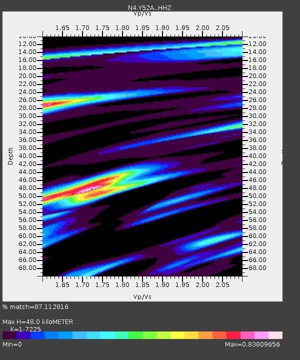
| Estimated Moho Depth: |
48.0 km |
| Estimated Crust Vp/Vs: |
1.72 |
| Assumed Crust Vp: |
6.719 km/s |
| Estimated Crust Vs: |
3.901 km/s |
| Estimated Crust Poisson's Ratio: |
0.25 |
|
| Radial Match: |
87.112816 % |
| Radial Bump: |
341 |
| Transverse Match: |
64.85613 % |
| Transverse Bump: |
400 |
| SOD ConfigId: |
11737051 |
| Insert Time: |
2019-04-25 03:42:30.414 +0000 |
| GWidth: |
2.5 |
| Max Bumps: |
400 |
| Tol: |
0.001 |
|

Signal To Noise
| Channel | StoN | STA | LTA |
| N4:Y52A: :HHZ:20160723T10:07:24.820007Z | 10.79539 | 6.278353E-7 | 5.815772E-8 |
| N4:Y52A: :HHN:20160723T10:07:24.820007Z | 6.2947598 | 2.5867953E-7 | 4.1094424E-8 |
| N4:Y52A: :HHE:20160723T10:07:24.820007Z | 6.161055 | 2.412516E-7 | 3.915751E-8 |
| Arrivals |
| Ps | 5.5 SECOND |
| PpPs | 18 SECOND |
| PsPs/PpSs | 24 SECOND |


