You are here: Home > Network List > TA - USArray Transportable Network (new EarthScope stations) Stations List
> Station Q24A Divide, CO, USA > Earthquake Result Viewer
Q24A Divide, CO, USA - Earthquake Result Viewer
*The percent match for this event was below the threshold and hence no stack was calculated.
| Earthquake location: |
Alaska Peninsula |
| Earthquake latitude/longitude: |
58.6/-156.6 |
| Earthquake time(UTC): |
2016/07/23 (205) 09:59:00 GMT |
| Earthquake Depth: |
204 km |
| Earthquake Magnitude: |
5.7 MB, 5.1 MI, 5.4 ML |
| Earthquake Catalog/Contributor: |
NEIC PDE/NEIC COMCAT |
|
| Network: |
TA USArray Transportable Network (new EarthScope stations) |
| Station: |
Q24A Divide, CO, USA |
| Lat/Lon: |
38.96 N/105.15 W |
| Elevation: |
2775 m |
|
| Distance: |
38.0 deg |
| Az: |
98.018 deg |
| Baz: |
318.256 deg |
| Ray Param: |
$rayparam |
*The percent match for this event was below the threshold and hence was not used in the summary stack. |
|
| Radial Match: |
78.55226 % |
| Radial Bump: |
400 |
| Transverse Match: |
63.40179 % |
| Transverse Bump: |
400 |
| SOD ConfigId: |
11737051 |
| Insert Time: |
2019-04-25 03:45:01.753 +0000 |
| GWidth: |
2.5 |
| Max Bumps: |
400 |
| Tol: |
0.001 |
|
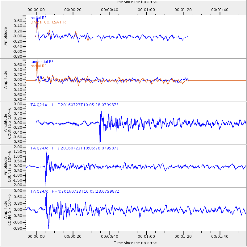
Signal To Noise
| Channel | StoN | STA | LTA |
| TA:Q24A: :HHZ:20160723T10:05:28.079987Z | 1.1154938 | 4.831215E-8 | 4.3310102E-8 |
| TA:Q24A: :HHN:20160723T10:05:28.079987Z | 2.142506 | 7.759451E-8 | 3.6216704E-8 |
| TA:Q24A: :HHE:20160723T10:05:28.079987Z | 1.0526166 | 4.2121446E-8 | 4.001594E-8 |
| Arrivals |
| Ps | |
| PpPs | |
| PsPs/PpSs | |


