You are here: Home > Network List > CI - Caltech Regional Seismic Network Stations List
> Station MPP McPhearson Peak > Earthquake Result Viewer
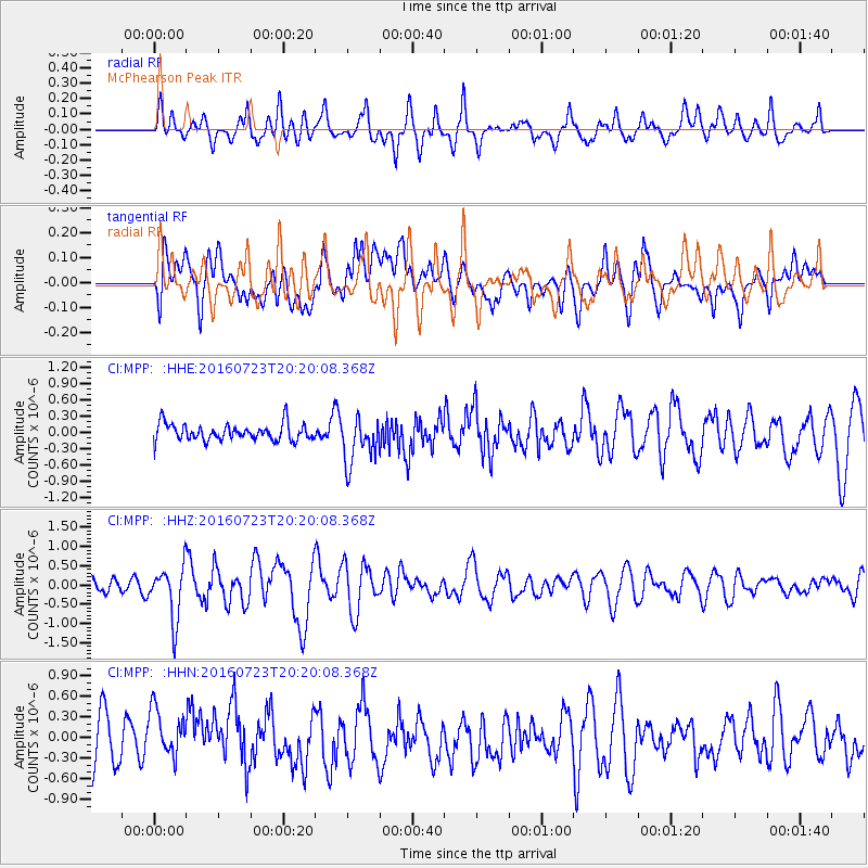
MPP McPhearson Peak - Earthquake Result Viewer
*The percent match for this event was below the threshold and hence no stack was calculated.
| Earthquake location: |
Tonga Islands |
| Earthquake latitude/longitude: |
-15.1/-173.6 |
| Earthquake time(UTC): |
2016/07/23 (205) 20:09:19 GMT |
| Earthquake Depth: |
10 km |
| Earthquake Magnitude: |
5.7 MB |
| Earthquake Catalog/Contributor: |
NEIC PDE/NEIC COMCAT |
|
| Network: |
CI Caltech Regional Seismic Network |
| Station: |
MPP McPhearson Peak |
| Lat/Lon: |
34.89 N/119.81 W |
| Elevation: |
1739 m |
|
| Distance: |
71.2 deg |
| Az: |
44.48 deg |
| Baz: |
235.416 deg |
| Ray Param: |
$rayparam |
*The percent match for this event was below the threshold and hence was not used in the summary stack. |
|
| Radial Match: |
78.32303 % |
| Radial Bump: |
400 |
| Transverse Match: |
50.3803 % |
| Transverse Bump: |
400 |
| SOD ConfigId: |
11737051 |
| Insert Time: |
2019-04-25 03:50:27.680 +0000 |
| GWidth: |
2.5 |
| Max Bumps: |
400 |
| Tol: |
0.001 |
|
Signal To Noise
| Channel | StoN | STA | LTA |
| CI:MPP: :HHZ:20160723T20:20:08.368Z | 1.9685088 | 6.745451E-7 | 3.4266805E-7 |
| CI:MPP: :HHN:20160723T20:20:08.368Z | 1.1971802 | 4.14441E-7 | 3.4618097E-7 |
| CI:MPP: :HHE:20160723T20:20:08.368Z | 2.9432352 | 4.5877312E-7 | 1.5587375E-7 |
| Arrivals |
| Ps | |
| PpPs | |
| PsPs/PpSs | |


