You are here: Home > Network List > GS - US Geological Survey Networks Stations List
> Station DEC06 Boomer, Decatur, IL, USA > Earthquake Result Viewer
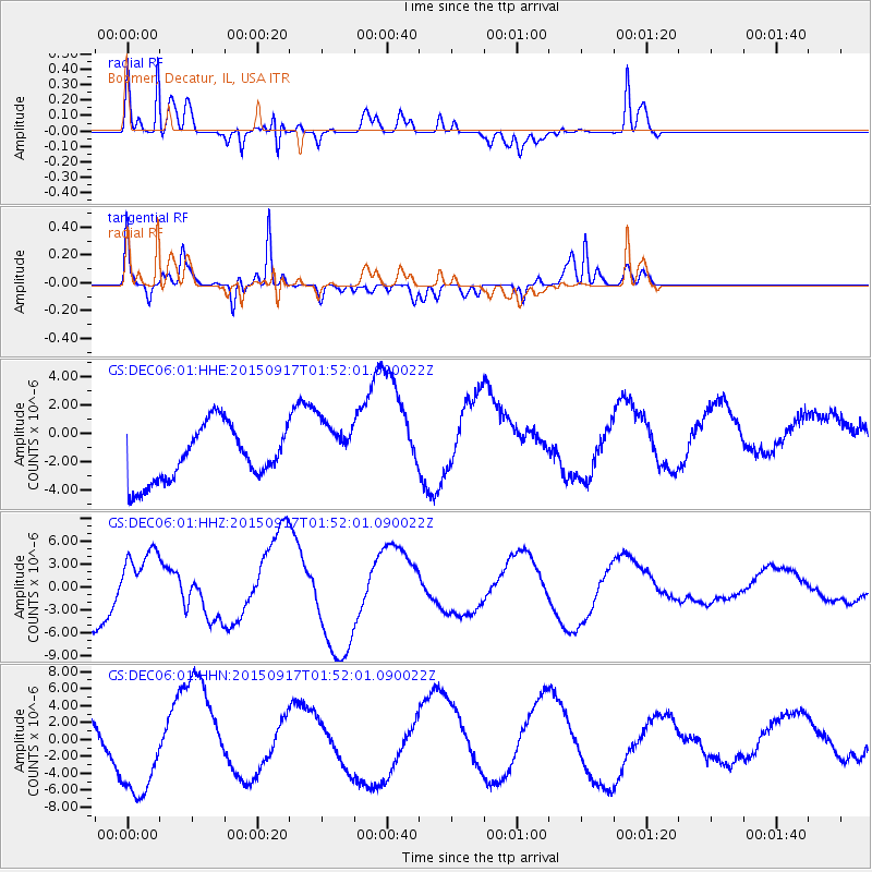
DEC06 Boomer, Decatur, IL, USA - Earthquake Result Viewer
*The percent match for this event was below the threshold and hence no stack was calculated.
| Earthquake location: |
Near Coast Of Central Chile |
| Earthquake latitude/longitude: |
-31.2/-71.6 |
| Earthquake time(UTC): |
2015/09/17 (260) 01:41:09 GMT |
| Earthquake Depth: |
37 km |
| Earthquake Magnitude: |
5.6 MB |
| Earthquake Catalog/Contributor: |
NEIC PDE/NEIC COMCAT |
|
| Network: |
GS US Geological Survey Networks |
| Station: |
DEC06 Boomer, Decatur, IL, USA |
| Lat/Lon: |
39.90 N/88.95 W |
| Elevation: |
215 m |
|
| Distance: |
72.5 deg |
| Az: |
346.088 deg |
| Baz: |
164.459 deg |
| Ray Param: |
$rayparam |
*The percent match for this event was below the threshold and hence was not used in the summary stack. |
|
| Radial Match: |
85.36499 % |
| Radial Bump: |
400 |
| Transverse Match: |
77.9707 % |
| Transverse Bump: |
400 |
| SOD ConfigId: |
1156111 |
| Insert Time: |
2015-10-01 02:56:52.000 +0000 |
| GWidth: |
2.5 |
| Max Bumps: |
400 |
| Tol: |
0.001 |
|
Signal To Noise
| Channel | StoN | STA | LTA |
| GS:DEC06:01:HHZ:20150917T01:52:01.090022Z | 1.5134072 | 4.0401546E-6 | 2.6695752E-6 |
| GS:DEC06:01:HHN:20150917T01:52:01.090022Z | 2.5205112 | 5.731199E-6 | 2.2738243E-6 |
| GS:DEC06:01:HHE:20150917T01:52:01.090022Z | 1.1026608 | 2.114173E-6 | 1.9173374E-6 |
| Arrivals |
| Ps | |
| PpPs | |
| PsPs/PpSs | |


