You are here: Home > Network List > IU - Global Seismograph Network (GSN - IRIS/USGS) Stations List
> Station POHA Pohakuloa, Hawaii, USA > Earthquake Result Viewer
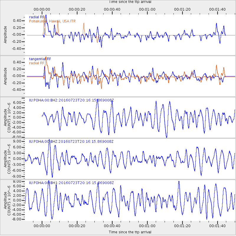
POHA Pohakuloa, Hawaii, USA - Earthquake Result Viewer
*The percent match for this event was below the threshold and hence no stack was calculated.
| Earthquake location: |
Tonga Islands |
| Earthquake latitude/longitude: |
-15.1/-173.6 |
| Earthquake time(UTC): |
2016/07/23 (205) 20:09:19 GMT |
| Earthquake Depth: |
10 km |
| Earthquake Magnitude: |
5.7 MB |
| Earthquake Catalog/Contributor: |
NEIC PDE/NEIC COMCAT |
|
| Network: |
IU Global Seismograph Network (GSN - IRIS/USGS) |
| Station: |
POHA Pohakuloa, Hawaii, USA |
| Lat/Lon: |
19.76 N/155.53 W |
| Elevation: |
1990 m |
|
| Distance: |
38.9 deg |
| Az: |
27.735 deg |
| Baz: |
208.508 deg |
| Ray Param: |
$rayparam |
*The percent match for this event was below the threshold and hence was not used in the summary stack. |
|
| Radial Match: |
73.63387 % |
| Radial Bump: |
400 |
| Transverse Match: |
40.654926 % |
| Transverse Bump: |
400 |
| SOD ConfigId: |
11737051 |
| Insert Time: |
2019-04-25 03:51:51.459 +0000 |
| GWidth: |
2.5 |
| Max Bumps: |
400 |
| Tol: |
0.001 |
|
Signal To Noise
| Channel | StoN | STA | LTA |
| IU:POHA:00:BHZ:20160723T20:16:15.869008Z | 2.725875 | 5.044191E-6 | 1.8504852E-6 |
| IU:POHA:00:BH1:20160723T20:16:15.869008Z | 1.8765218 | 4.8728366E-6 | 2.5967386E-6 |
| IU:POHA:00:BH2:20160723T20:16:15.869008Z | 2.0046864 | 3.7971893E-6 | 1.8941563E-6 |
| Arrivals |
| Ps | |
| PpPs | |
| PsPs/PpSs | |


