You are here: Home > Network List > US - United States National Seismic Network Stations List
> Station EGAK Eagle, Central Alaska, Alaska, USA > Earthquake Result Viewer
EGAK Eagle, Central Alaska, Alaska, USA - Earthquake Result Viewer
| Earthquake location: |
Irian Jaya Region, Indonesia |
| Earthquake latitude/longitude: |
-0.7/133.3 |
| Earthquake time(UTC): |
2009/01/03 (003) 22:33:40 GMT |
| Earthquake Depth: |
23 km |
| Earthquake Magnitude: |
6.7 MB, 7.4 MS, 7.4 MW, 7.3 MW |
| Earthquake Catalog/Contributor: |
WHDF/NEIC |
|
| Network: |
US United States National Seismic Network |
| Station: |
EGAK Eagle, Central Alaska, Alaska, USA |
| Lat/Lon: |
64.78 N/141.16 W |
| Elevation: |
297 m |
|
| Distance: |
88.7 deg |
| Az: |
25.296 deg |
| Baz: |
265.672 deg |
| Ray Param: |
0.04236102 |
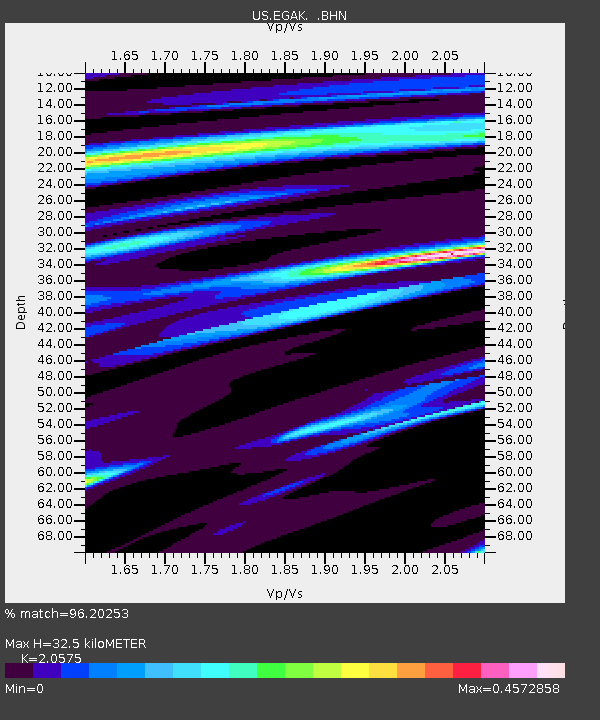
| Estimated Moho Depth: |
32.5 km |
| Estimated Crust Vp/Vs: |
2.06 |
| Assumed Crust Vp: |
6.566 km/s |
| Estimated Crust Vs: |
3.191 km/s |
| Estimated Crust Poisson's Ratio: |
0.35 |
|
| Radial Match: |
96.20253 % |
| Radial Bump: |
276 |
| Transverse Match: |
83.43061 % |
| Transverse Bump: |
400 |
| SOD ConfigId: |
2834 |
| Insert Time: |
2010-03-05 05:38:26.086 +0000 |
| GWidth: |
2.5 |
| Max Bumps: |
400 |
| Tol: |
0.001 |
|

Signal To Noise
| Channel | StoN | STA | LTA |
| US:EGAK: :BHN:20090103T22:46:00.349021Z | 4.256101 | 2.940814E-6 | 6.909644E-7 |
| US:EGAK: :BHE:20090103T22:46:00.349021Z | 2.0134585 | 7.414022E-7 | 3.6822323E-7 |
| US:EGAK: :BHZ:20090103T22:46:00.349021Z | 5.75539 | 1.834107E-6 | 3.186764E-7 |
| Arrivals |
| Ps | 5.3 SECOND |
| PpPs | 15 SECOND |
| PsPs/PpSs | 20 SECOND |


