You are here: Home > Network List > NN - Western Great Basin/Eastern Sierra Nevada Stations List
> Station CMK6 Chalk Mountain, Churchill County, NV, USA > Earthquake Result Viewer
CMK6 Chalk Mountain, Churchill County, NV, USA - Earthquake Result Viewer
| Earthquake location: |
Tonga Islands |
| Earthquake latitude/longitude: |
-15.1/-173.6 |
| Earthquake time(UTC): |
2016/07/23 (205) 20:09:19 GMT |
| Earthquake Depth: |
10 km |
| Earthquake Magnitude: |
5.7 MB |
| Earthquake Catalog/Contributor: |
NEIC PDE/NEIC COMCAT |
|
| Network: |
NN Western Great Basin/Eastern Sierra Nevada |
| Station: |
CMK6 Chalk Mountain, Churchill County, NV, USA |
| Lat/Lon: |
39.31 N/118.12 W |
| Elevation: |
1332 m |
|
| Distance: |
74.9 deg |
| Az: |
41.482 deg |
| Baz: |
235.56 deg |
| Ray Param: |
0.052047867 |
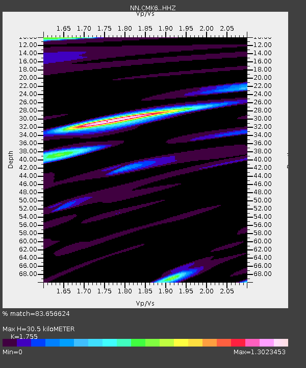
| Estimated Moho Depth: |
30.5 km |
| Estimated Crust Vp/Vs: |
1.75 |
| Assumed Crust Vp: |
6.279 km/s |
| Estimated Crust Vs: |
3.578 km/s |
| Estimated Crust Poisson's Ratio: |
0.26 |
|
| Radial Match: |
83.656624 % |
| Radial Bump: |
400 |
| Transverse Match: |
78.17007 % |
| Transverse Bump: |
400 |
| SOD ConfigId: |
11737051 |
| Insert Time: |
2019-04-25 03:52:43.570 +0000 |
| GWidth: |
2.5 |
| Max Bumps: |
400 |
| Tol: |
0.001 |
|

Signal To Noise
| Channel | StoN | STA | LTA |
| NN:CMK6: :HHZ:20160723T20:20:29.675007Z | 20.892132 | 3.5888607E-7 | 1.717805E-8 |
| NN:CMK6: :HHN:20160723T20:20:29.675007Z | 2.2459924 | 6.787269E-8 | 3.0219464E-8 |
| NN:CMK6: :HHE:20160723T20:20:29.675007Z | 3.0294201 | 8.858494E-8 | 2.924155E-8 |
| Arrivals |
| Ps | 3.8 SECOND |
| PpPs | 13 SECOND |
| PsPs/PpSs | 17 SECOND |


