You are here: Home > Network List > TA - USArray Transportable Network (new EarthScope stations) Stations List
> Station G23K Bananza Creek, AK, USA > Earthquake Result Viewer
G23K Bananza Creek, AK, USA - Earthquake Result Viewer

| Earthquake location: |
Tonga Islands |
| Earthquake latitude/longitude: |
-15.1/-173.6 |
| Earthquake time(UTC): |
2016/07/23 (205) 20:09:19 GMT |
| Earthquake Depth: |
10 km |
| Earthquake Magnitude: |
5.7 MB |
| Earthquake Catalog/Contributor: |
NEIC PDE/NEIC COMCAT |
|
| Network: |
TA USArray Transportable Network (new EarthScope stations) |
| Station: |
G23K Bananza Creek, AK, USA |
| Lat/Lon: |
66.71 N/150.02 W |
| Elevation: |
746 m |
|
| Distance: |
83.4 deg |
| Az: |
9.221 deg |
| Baz: |
202.909 deg |
| Ray Param: |
0.04619821 |
| Estimated Moho Depth: |
35.25 km |
| Estimated Crust Vp/Vs: |
1.69 |
| Assumed Crust Vp: |
6.577 km/s |
| Estimated Crust Vs: |
3.903 km/s |
| Estimated Crust Poisson's Ratio: |
0.23 |
|
| Radial Match: |
87.84121 % |
| Radial Bump: |
400 |
| Transverse Match: |
70.80529 % |
| Transverse Bump: |
400 |
| SOD ConfigId: |
11737051 |
| Insert Time: |
2019-04-25 03:54:35.347 +0000 |
| GWidth: |
2.5 |
| Max Bumps: |
400 |
| Tol: |
0.001 |
|
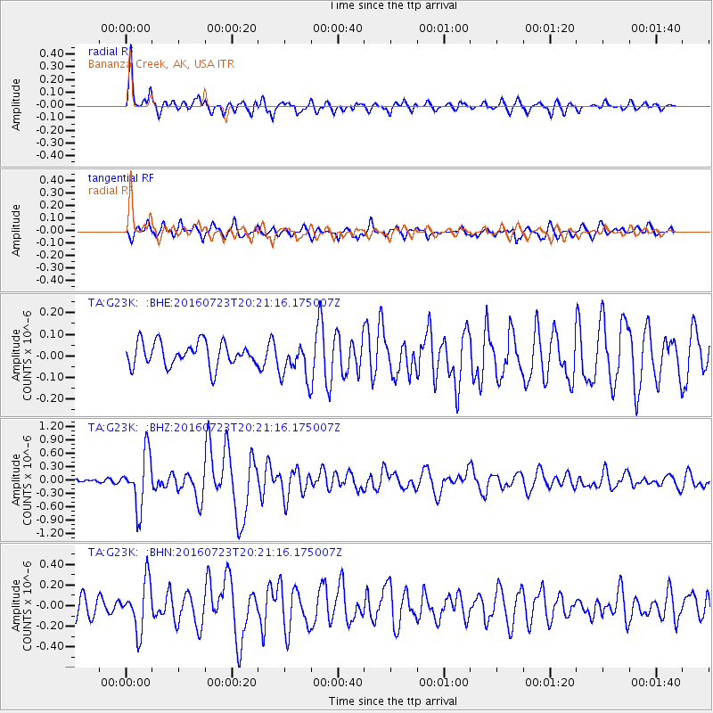
Signal To Noise
| Channel | StoN | STA | LTA |
| TA:G23K: :BHZ:20160723T20:21:16.175007Z | 13.9882965 | 6.0235936E-7 | 4.3061668E-8 |
| TA:G23K: :BHN:20160723T20:21:16.175007Z | 3.6563506 | 2.3917494E-7 | 6.5413566E-8 |
| TA:G23K: :BHE:20160723T20:21:16.175007Z | 1.1545981 | 6.3736884E-8 | 5.520266E-8 |
| Arrivals |
| Ps | 3.8 SECOND |
| PpPs | 14 SECOND |
| PsPs/PpSs | 18 SECOND |


