You are here: Home > Network List > TA - USArray Transportable Network (new EarthScope stations) Stations List
> Station MSTX Muleshoe, TX, USA > Earthquake Result Viewer
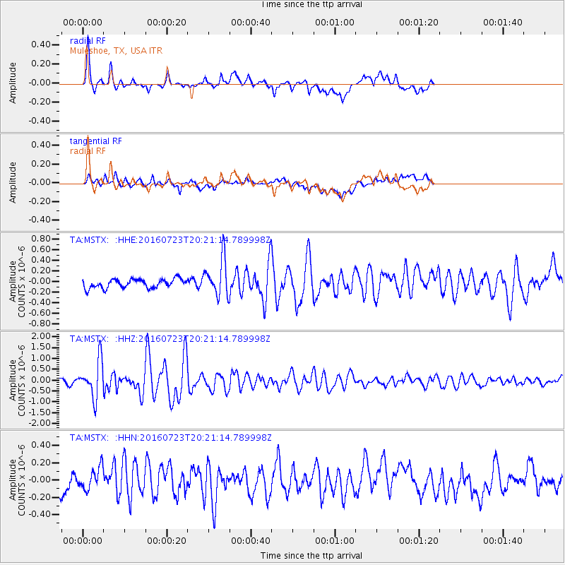
MSTX Muleshoe, TX, USA - Earthquake Result Viewer
*The percent match for this event was below the threshold and hence no stack was calculated.
| Earthquake location: |
Tonga Islands |
| Earthquake latitude/longitude: |
-15.1/-173.6 |
| Earthquake time(UTC): |
2016/07/23 (205) 20:09:19 GMT |
| Earthquake Depth: |
10 km |
| Earthquake Magnitude: |
5.7 MB |
| Earthquake Catalog/Contributor: |
NEIC PDE/NEIC COMCAT |
|
| Network: |
TA USArray Transportable Network (new EarthScope stations) |
| Station: |
MSTX Muleshoe, TX, USA |
| Lat/Lon: |
33.97 N/102.77 W |
| Elevation: |
1167 m |
|
| Distance: |
83.1 deg |
| Az: |
52.255 deg |
| Baz: |
246.791 deg |
| Ray Param: |
$rayparam |
*The percent match for this event was below the threshold and hence was not used in the summary stack. |
|
| Radial Match: |
86.5967 % |
| Radial Bump: |
400 |
| Transverse Match: |
62.049835 % |
| Transverse Bump: |
400 |
| SOD ConfigId: |
11737051 |
| Insert Time: |
2019-04-25 03:55:05.231 +0000 |
| GWidth: |
2.5 |
| Max Bumps: |
400 |
| Tol: |
0.001 |
|
Signal To Noise
| Channel | StoN | STA | LTA |
| TA:MSTX: :HHZ:20160723T20:21:14.789998Z | 7.101532 | 8.6336365E-7 | 1.2157427E-7 |
| TA:MSTX: :HHN:20160723T20:21:14.789998Z | 1.2150884 | 1.4193621E-7 | 1.1681143E-7 |
| TA:MSTX: :HHE:20160723T20:21:14.789998Z | 4.0040636 | 3.4413245E-7 | 8.59458E-8 |
| Arrivals |
| Ps | |
| PpPs | |
| PsPs/PpSs | |


