You are here: Home > Network List > TA - USArray Transportable Network (new EarthScope stations) Stations List
> Station O17K Koliganek, Bristol Bay, AK, USA > Earthquake Result Viewer
O17K Koliganek, Bristol Bay, AK, USA - Earthquake Result Viewer
| Earthquake location: |
Tonga Islands |
| Earthquake latitude/longitude: |
-15.1/-173.6 |
| Earthquake time(UTC): |
2016/07/23 (205) 20:09:19 GMT |
| Earthquake Depth: |
10 km |
| Earthquake Magnitude: |
5.7 MB |
| Earthquake Catalog/Contributor: |
NEIC PDE/NEIC COMCAT |
|
| Network: |
TA USArray Transportable Network (new EarthScope stations) |
| Station: |
O17K Koliganek, Bristol Bay, AK, USA |
| Lat/Lon: |
59.77 N/157.09 W |
| Elevation: |
156 m |
|
| Distance: |
75.8 deg |
| Az: |
8.539 deg |
| Baz: |
196.468 deg |
| Ray Param: |
0.05142478 |
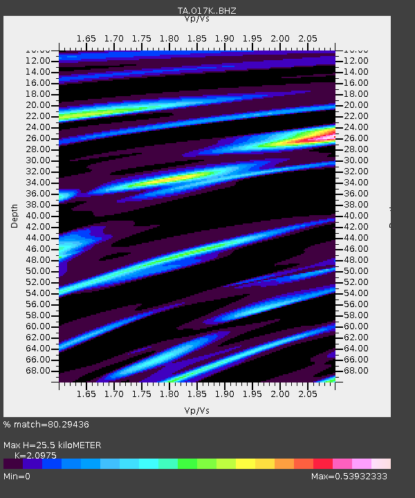
| Estimated Moho Depth: |
25.5 km |
| Estimated Crust Vp/Vs: |
2.10 |
| Assumed Crust Vp: |
6.276 km/s |
| Estimated Crust Vs: |
2.992 km/s |
| Estimated Crust Poisson's Ratio: |
0.35 |
|
| Radial Match: |
80.29436 % |
| Radial Bump: |
360 |
| Transverse Match: |
67.10163 % |
| Transverse Bump: |
348 |
| SOD ConfigId: |
11737051 |
| Insert Time: |
2019-04-25 03:55:10.970 +0000 |
| GWidth: |
2.5 |
| Max Bumps: |
400 |
| Tol: |
0.001 |
|
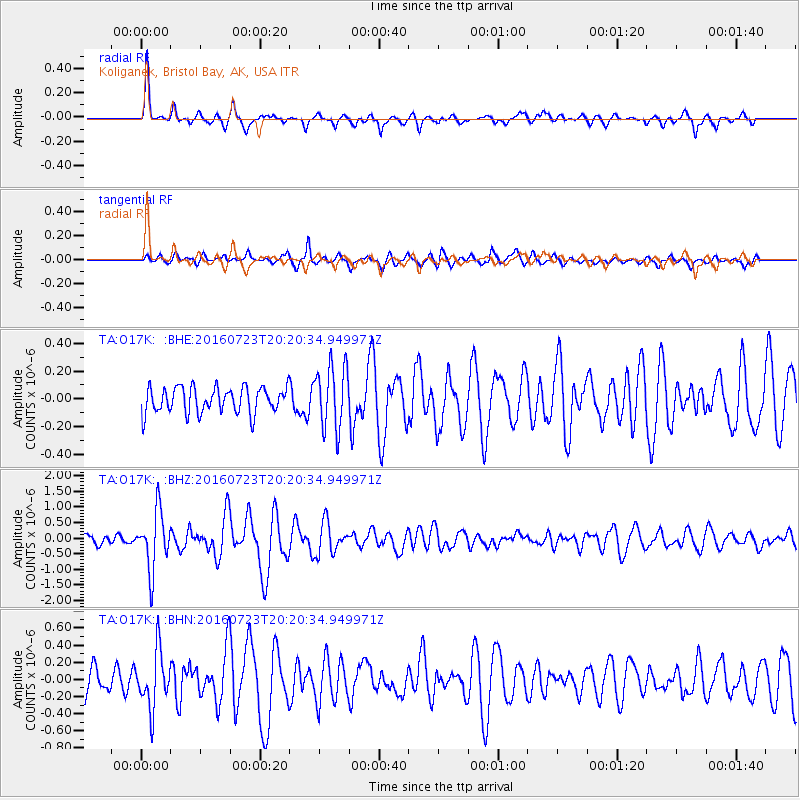
Signal To Noise
| Channel | StoN | STA | LTA |
| TA:O17K: :BHZ:20160723T20:20:34.949971Z | 6.710448 | 9.1782545E-7 | 1.3677558E-7 |
| TA:O17K: :BHN:20160723T20:20:34.949971Z | 1.7353083 | 3.2663397E-7 | 1.882282E-7 |
| TA:O17K: :BHE:20160723T20:20:34.949971Z | 2.194946 | 2.0304509E-7 | 9.250573E-8 |
| Arrivals |
| Ps | 4.6 SECOND |
| PpPs | 12 SECOND |
| PsPs/PpSs | 17 SECOND |


