You are here: Home > Network List > UW - Pacific Northwest Regional Seismic Network Stations List
> Station MRBL Marblemount, WA, USA > Earthquake Result Viewer
MRBL Marblemount, WA, USA - Earthquake Result Viewer
*The percent match for this event was below the threshold and hence no stack was calculated.
| Earthquake location: |
Tonga Islands |
| Earthquake latitude/longitude: |
-15.1/-173.6 |
| Earthquake time(UTC): |
2016/07/23 (205) 20:09:19 GMT |
| Earthquake Depth: |
10 km |
| Earthquake Magnitude: |
5.7 MB |
| Earthquake Catalog/Contributor: |
NEIC PDE/NEIC COMCAT |
|
| Network: |
UW Pacific Northwest Regional Seismic Network |
| Station: |
MRBL Marblemount, WA, USA |
| Lat/Lon: |
48.52 N/121.48 W |
| Elevation: |
75 m |
|
| Distance: |
78.4 deg |
| Az: |
32.401 deg |
| Baz: |
231.122 deg |
| Ray Param: |
$rayparam |
*The percent match for this event was below the threshold and hence was not used in the summary stack. |
|
| Radial Match: |
76.88618 % |
| Radial Bump: |
400 |
| Transverse Match: |
70.60741 % |
| Transverse Bump: |
400 |
| SOD ConfigId: |
11737051 |
| Insert Time: |
2019-04-25 03:56:17.879 +0000 |
| GWidth: |
2.5 |
| Max Bumps: |
400 |
| Tol: |
0.001 |
|
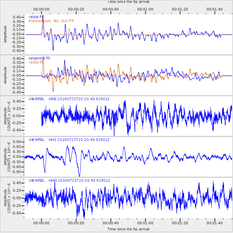
Signal To Noise
| Channel | StoN | STA | LTA |
| UW:MRBL: :HHZ:20160723T20:20:49.62801Z | 6.536578 | 3.857088E-7 | 5.9007753E-8 |
| UW:MRBL: :HHN:20160723T20:20:49.62801Z | 1.1124597 | 1.1615212E-7 | 1.0441019E-7 |
| UW:MRBL: :HHE:20160723T20:20:49.62801Z | 1.2632401 | 1.3771215E-7 | 1.09015026E-7 |
| Arrivals |
| Ps | |
| PpPs | |
| PsPs/PpSs | |


