You are here: Home > Network List > UW - Pacific Northwest Regional Seismic Network Stations List
> Station PASS Maple Falls, WA, USA > Earthquake Result Viewer
PASS Maple Falls, WA, USA - Earthquake Result Viewer

| Earthquake location: |
Tonga Islands |
| Earthquake latitude/longitude: |
-15.1/-173.6 |
| Earthquake time(UTC): |
2016/07/23 (205) 20:09:19 GMT |
| Earthquake Depth: |
10 km |
| Earthquake Magnitude: |
5.7 MB |
| Earthquake Catalog/Contributor: |
NEIC PDE/NEIC COMCAT |
|
| Network: |
UW Pacific Northwest Regional Seismic Network |
| Station: |
PASS Maple Falls, WA, USA |
| Lat/Lon: |
49.00 N/122.09 W |
| Elevation: |
174 m |
|
| Distance: |
78.4 deg |
| Az: |
31.765 deg |
| Baz: |
230.544 deg |
| Ray Param: |
0.04966255 |
| Estimated Moho Depth: |
27.25 km |
| Estimated Crust Vp/Vs: |
2.02 |
| Assumed Crust Vp: |
6.566 km/s |
| Estimated Crust Vs: |
3.251 km/s |
| Estimated Crust Poisson's Ratio: |
0.34 |
|
| Radial Match: |
81.4871 % |
| Radial Bump: |
400 |
| Transverse Match: |
71.898834 % |
| Transverse Bump: |
400 |
| SOD ConfigId: |
11737051 |
| Insert Time: |
2019-04-25 03:56:19.288 +0000 |
| GWidth: |
2.5 |
| Max Bumps: |
400 |
| Tol: |
0.001 |
|
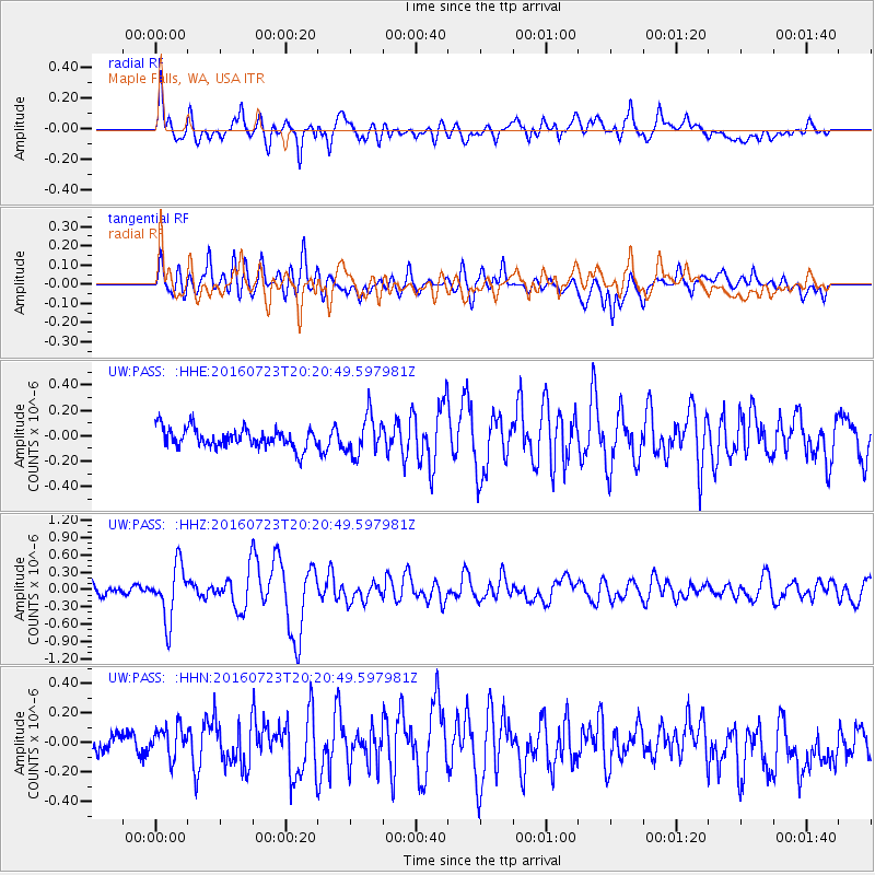
Signal To Noise
| Channel | StoN | STA | LTA |
| UW:PASS: :HHZ:20160723T20:20:49.597981Z | 5.5883656 | 4.704195E-7 | 8.4178374E-8 |
| UW:PASS: :HHN:20160723T20:20:49.597981Z | 2.0875447 | 1.2013564E-7 | 5.7548775E-8 |
| UW:PASS: :HHE:20160723T20:20:49.597981Z | 1.9386721 | 1.5016722E-7 | 7.745881E-8 |
| Arrivals |
| Ps | 4.3 SECOND |
| PpPs | 12 SECOND |
| PsPs/PpSs | 17 SECOND |


