You are here: Home > Network List > IU - Global Seismograph Network (GSN - IRIS/USGS) Stations List
> Station RSSD Black Hills, South Dakota, USA > Earthquake Result Viewer
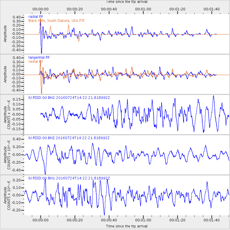
RSSD Black Hills, South Dakota, USA - Earthquake Result Viewer
*The percent match for this event was below the threshold and hence no stack was calculated.
| Earthquake location: |
Central Mid-Atlantic Ridge |
| Earthquake latitude/longitude: |
0.9/-29.0 |
| Earthquake time(UTC): |
2016/07/24 (206) 14:10:51 GMT |
| Earthquake Depth: |
10 km |
| Earthquake Magnitude: |
5.7 mwb |
| Earthquake Catalog/Contributor: |
NEIC PDE/ |
|
| Network: |
IU Global Seismograph Network (GSN - IRIS/USGS) |
| Station: |
RSSD Black Hills, South Dakota, USA |
| Lat/Lon: |
44.12 N/104.04 W |
| Elevation: |
2090 m |
|
| Distance: |
78.7 deg |
| Az: |
314.788 deg |
| Baz: |
99.827 deg |
| Ray Param: |
$rayparam |
*The percent match for this event was below the threshold and hence was not used in the summary stack. |
|
| Radial Match: |
62.195408 % |
| Radial Bump: |
400 |
| Transverse Match: |
71.70117 % |
| Transverse Bump: |
400 |
| SOD ConfigId: |
11737051 |
| Insert Time: |
2019-04-25 04:03:16.147 +0000 |
| GWidth: |
2.5 |
| Max Bumps: |
400 |
| Tol: |
0.001 |
|
Signal To Noise
| Channel | StoN | STA | LTA |
| IU:RSSD:00:BHZ:20160724T14:22:21.818992Z | 3.338461 | 2.3093418E-7 | 6.917384E-8 |
| IU:RSSD:00:BH1:20160724T14:22:21.818992Z | 1.8315433 | 8.412587E-8 | 4.5931685E-8 |
| IU:RSSD:00:BH2:20160724T14:22:21.818992Z | 1.4916315 | 4.9432032E-8 | 3.313957E-8 |
| Arrivals |
| Ps | |
| PpPs | |
| PsPs/PpSs | |


