You are here: Home > Network List > CU - Caribbean Network (USGS) Stations List
> Station SDDR Presa de Sabaneta, Dominican Republic > Earthquake Result Viewer
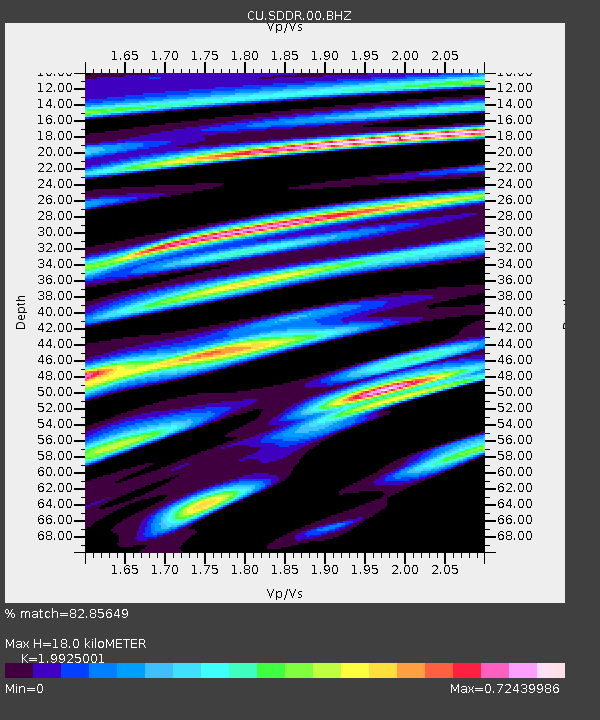
SDDR Presa de Sabaneta, Dominican Republic - Earthquake Result Viewer
| Earthquake location: |
Near Coast Of Central Chile |
| Earthquake latitude/longitude: |
-31.0/-71.4 |
| Earthquake time(UTC): |
2015/09/17 (260) 03:55:07 GMT |
| Earthquake Depth: |
35 km |
| Earthquake Magnitude: |
6.2 MO |
| Earthquake Catalog/Contributor: |
NEIC PDE/NEIC ALERT |
|
| Network: |
CU Caribbean Network (USGS) |
| Station: |
SDDR Presa de Sabaneta, Dominican Republic |
| Lat/Lon: |
18.98 N/71.29 W |
| Elevation: |
589 m |
|
| Distance: |
49.7 deg |
| Az: |
0.091 deg |
| Baz: |
180.082 deg |
| Ray Param: |
0.06848717 |
| Estimated Moho Depth: |
18.0 km |
| Estimated Crust Vp/Vs: |
1.99 |
| Assumed Crust Vp: |
6.448 km/s |
| Estimated Crust Vs: |
3.236 km/s |
| Estimated Crust Poisson's Ratio: |
0.33 |
|
| Radial Match: |
82.85649 % |
| Radial Bump: |
400 |
| Transverse Match: |
67.92827 % |
| Transverse Bump: |
400 |
| SOD ConfigId: |
1156111 |
| Insert Time: |
2015-10-01 04:20:41.730 +0000 |
| GWidth: |
2.5 |
| Max Bumps: |
400 |
| Tol: |
0.001 |
|

Signal To Noise
| Channel | StoN | STA | LTA |
| CU:SDDR:00:BHZ:20150917T04:03:24.948993Z | 1.8761406 | 2.5742702E-7 | 1.3721095E-7 |
| CU:SDDR:00:BH1:20150917T04:03:24.948993Z | 1.1044465 | 2.7188847E-7 | 2.4617623E-7 |
| CU:SDDR:00:BH2:20150917T04:03:24.948993Z | 1.3622388 | 2.9339344E-7 | 2.1537592E-7 |
| Arrivals |
| Ps | 2.9 SECOND |
| PpPs | 7.9 SECOND |
| PsPs/PpSs | 11 SECOND |


