You are here: Home > Network List > NM - Cooperative New Madrid Seismic Network Stations List
> Station HDAR2 I40 Weigh Station,West Memphis,AR > Earthquake Result Viewer
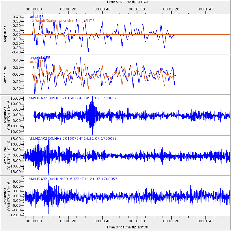
HDAR2 I40 Weigh Station,West Memphis,AR - Earthquake Result Viewer
*The percent match for this event was below the threshold and hence no stack was calculated.
| Earthquake location: |
Central Mid-Atlantic Ridge |
| Earthquake latitude/longitude: |
0.9/-29.0 |
| Earthquake time(UTC): |
2016/07/24 (206) 14:10:51 GMT |
| Earthquake Depth: |
10 km |
| Earthquake Magnitude: |
5.7 mwb |
| Earthquake Catalog/Contributor: |
NEIC PDE/ |
|
| Network: |
NM Cooperative New Madrid Seismic Network |
| Station: |
HDAR2 I40 Weigh Station,West Memphis,AR |
| Lat/Lon: |
35.15 N/90.09 W |
| Elevation: |
100 m |
|
| Distance: |
66.1 deg |
| Az: |
308.309 deg |
| Baz: |
106.768 deg |
| Ray Param: |
$rayparam |
*The percent match for this event was below the threshold and hence was not used in the summary stack. |
|
| Radial Match: |
32.15177 % |
| Radial Bump: |
400 |
| Transverse Match: |
65.43594 % |
| Transverse Bump: |
400 |
| SOD ConfigId: |
11737051 |
| Insert Time: |
2019-04-25 04:05:52.094 +0000 |
| GWidth: |
2.5 |
| Max Bumps: |
400 |
| Tol: |
0.001 |
|
Signal To Noise
| Channel | StoN | STA | LTA |
| NM:HDAR2:00:HHZ:20160724T14:21:07.170005Z | 2.8934813 | 6.271701E-6 | 2.1675278E-6 |
| NM:HDAR2:00:HHN:20160724T14:21:07.170005Z | 1.1346182 | 2.3864563E-6 | 2.1033125E-6 |
| NM:HDAR2:00:HHE:20160724T14:21:07.170005Z | 3.034836 | 6.644291E-6 | 2.1893409E-6 |
| Arrivals |
| Ps | |
| PpPs | |
| PsPs/PpSs | |


