You are here: Home > Network List > TA - USArray Transportable Network (new EarthScope stations) Stations List
> Station 833A Chaparral WMA, Artesia Wells, TX, USA > Earthquake Result Viewer
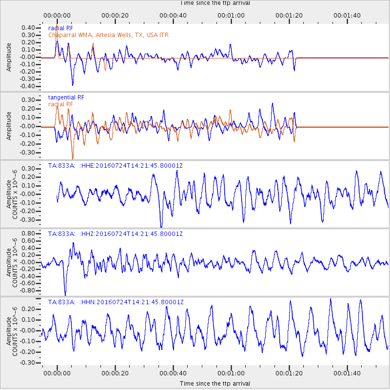
833A Chaparral WMA, Artesia Wells, TX, USA - Earthquake Result Viewer
*The percent match for this event was below the threshold and hence no stack was calculated.
| Earthquake location: |
Central Mid-Atlantic Ridge |
| Earthquake latitude/longitude: |
0.9/-29.0 |
| Earthquake time(UTC): |
2016/07/24 (206) 14:10:51 GMT |
| Earthquake Depth: |
10 km |
| Earthquake Magnitude: |
5.7 mwb |
| Earthquake Catalog/Contributor: |
NEIC PDE/ |
|
| Network: |
TA USArray Transportable Network (new EarthScope stations) |
| Station: |
833A Chaparral WMA, Artesia Wells, TX, USA |
| Lat/Lon: |
28.32 N/99.39 W |
| Elevation: |
171 m |
|
| Distance: |
72.4 deg |
| Az: |
299.358 deg |
| Baz: |
98.699 deg |
| Ray Param: |
$rayparam |
*The percent match for this event was below the threshold and hence was not used in the summary stack. |
|
| Radial Match: |
64.08611 % |
| Radial Bump: |
400 |
| Transverse Match: |
50.61318 % |
| Transverse Bump: |
338 |
| SOD ConfigId: |
11737051 |
| Insert Time: |
2019-04-25 04:07:55.917 +0000 |
| GWidth: |
2.5 |
| Max Bumps: |
400 |
| Tol: |
0.001 |
|
Signal To Noise
| Channel | StoN | STA | LTA |
| TA:833A: :HHZ:20160724T14:21:45.80001Z | 4.118306 | 3.263474E-7 | 7.9243115E-8 |
| TA:833A: :HHN:20160724T14:21:45.80001Z | 0.65562624 | 7.584874E-8 | 1.1568899E-7 |
| TA:833A: :HHE:20160724T14:21:45.80001Z | 1.89616 | 1.1503763E-7 | 6.066874E-8 |
| Arrivals |
| Ps | |
| PpPs | |
| PsPs/PpSs | |


