You are here: Home > Network List > TA - USArray Transportable Network (new EarthScope stations) Stations List
> Station M53A WI Miller and Sons, Farmdale, OH, USA > Earthquake Result Viewer
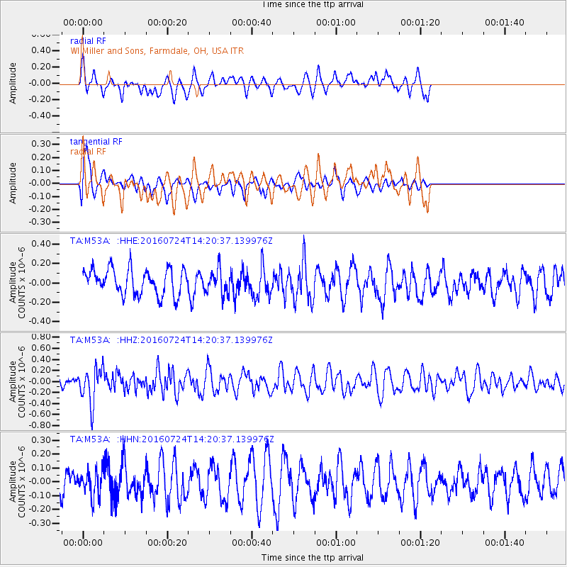
M53A WI Miller and Sons, Farmdale, OH, USA - Earthquake Result Viewer
*The percent match for this event was below the threshold and hence no stack was calculated.
| Earthquake location: |
Central Mid-Atlantic Ridge |
| Earthquake latitude/longitude: |
0.9/-29.0 |
| Earthquake time(UTC): |
2016/07/24 (206) 14:10:51 GMT |
| Earthquake Depth: |
10 km |
| Earthquake Magnitude: |
5.7 mwb |
| Earthquake Catalog/Contributor: |
NEIC PDE/ |
|
| Network: |
TA USArray Transportable Network (new EarthScope stations) |
| Station: |
M53A WI Miller and Sons, Farmdale, OH, USA |
| Lat/Lon: |
41.44 N/80.68 W |
| Elevation: |
334 m |
|
| Distance: |
61.6 deg |
| Az: |
317.847 deg |
| Baz: |
116.813 deg |
| Ray Param: |
$rayparam |
*The percent match for this event was below the threshold and hence was not used in the summary stack. |
|
| Radial Match: |
66.49242 % |
| Radial Bump: |
400 |
| Transverse Match: |
70.89711 % |
| Transverse Bump: |
380 |
| SOD ConfigId: |
11737051 |
| Insert Time: |
2019-04-25 04:08:09.034 +0000 |
| GWidth: |
2.5 |
| Max Bumps: |
400 |
| Tol: |
0.001 |
|
Signal To Noise
| Channel | StoN | STA | LTA |
| TA:M53A: :HHZ:20160724T14:20:37.139976Z | 1.8429854 | 3.2949612E-7 | 1.7878389E-7 |
| TA:M53A: :HHN:20160724T14:20:37.139976Z | 0.73352796 | 9.638057E-8 | 1.3139318E-7 |
| TA:M53A: :HHE:20160724T14:20:37.139976Z | 0.9742426 | 1.2997513E-7 | 1.3341148E-7 |
| Arrivals |
| Ps | |
| PpPs | |
| PsPs/PpSs | |


