You are here: Home > Network List > US - United States National Seismic Network Stations List
> Station MNTX Cornudas Mountains, Texas, USA > Earthquake Result Viewer
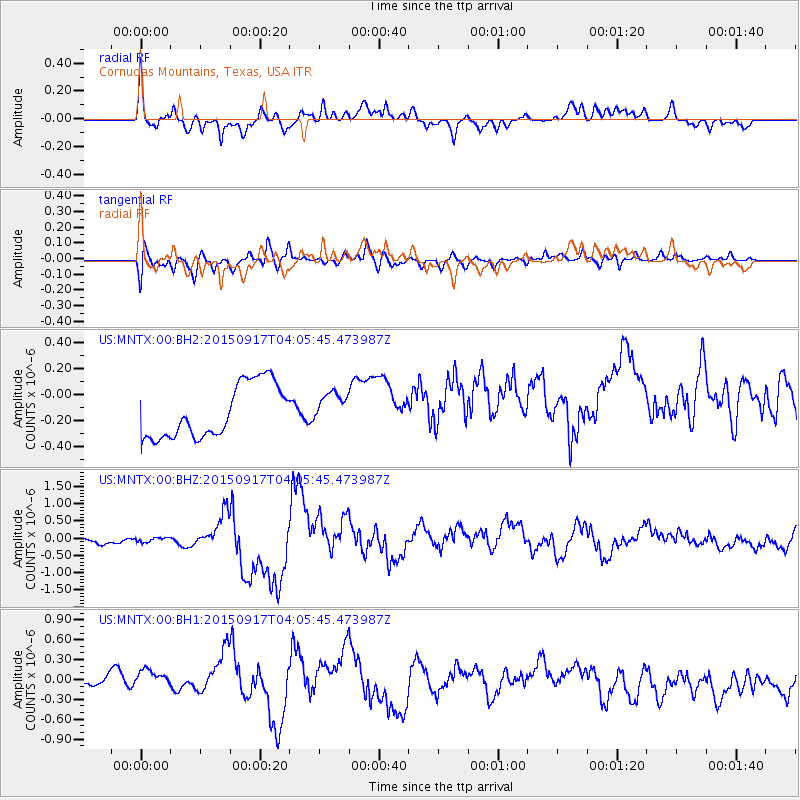
MNTX Cornudas Mountains, Texas, USA - Earthquake Result Viewer
*The percent match for this event was below the threshold and hence no stack was calculated.
| Earthquake location: |
Near Coast Of Central Chile |
| Earthquake latitude/longitude: |
-31.0/-71.4 |
| Earthquake time(UTC): |
2015/09/17 (260) 03:55:07 GMT |
| Earthquake Depth: |
35 km |
| Earthquake Magnitude: |
6.2 MO |
| Earthquake Catalog/Contributor: |
NEIC PDE/NEIC ALERT |
|
| Network: |
US United States National Seismic Network |
| Station: |
MNTX Cornudas Mountains, Texas, USA |
| Lat/Lon: |
31.70 N/105.38 W |
| Elevation: |
404 m |
|
| Distance: |
70.2 deg |
| Az: |
329.539 deg |
| Baz: |
149.28 deg |
| Ray Param: |
$rayparam |
*The percent match for this event was below the threshold and hence was not used in the summary stack. |
|
| Radial Match: |
61.63285 % |
| Radial Bump: |
394 |
| Transverse Match: |
42.209137 % |
| Transverse Bump: |
400 |
| SOD ConfigId: |
1156111 |
| Insert Time: |
2015-10-01 04:25:17.729 +0000 |
| GWidth: |
2.5 |
| Max Bumps: |
400 |
| Tol: |
0.001 |
|
Signal To Noise
| Channel | StoN | STA | LTA |
| US:MNTX:00:BHZ:20150917T04:05:45.473987Z | 0.8972811 | 1.500676E-7 | 1.6724704E-7 |
| US:MNTX:00:BH1:20150917T04:05:45.473987Z | 1.2847941 | 3.1504757E-7 | 2.452125E-7 |
| US:MNTX:00:BH2:20150917T04:05:45.473987Z | 0.6023335 | 1.2325965E-7 | 2.0463689E-7 |
| Arrivals |
| Ps | |
| PpPs | |
| PsPs/PpSs | |


