You are here: Home > Network List > UU - University of Utah Regional Network Stations List
> Station CCUT Cedar City, UT, USA > Earthquake Result Viewer
CCUT Cedar City, UT, USA - Earthquake Result Viewer

| Earthquake location: |
Near Coast Of Central Chile |
| Earthquake latitude/longitude: |
-31.0/-71.4 |
| Earthquake time(UTC): |
2015/09/17 (260) 03:55:07 GMT |
| Earthquake Depth: |
35 km |
| Earthquake Magnitude: |
6.2 MO |
| Earthquake Catalog/Contributor: |
NEIC PDE/NEIC ALERT |
|
| Network: |
UU University of Utah Regional Network |
| Station: |
CCUT Cedar City, UT, USA |
| Lat/Lon: |
37.55 N/113.36 W |
| Elevation: |
2127 m |
|
| Distance: |
78.7 deg |
| Az: |
327.152 deg |
| Baz: |
144.113 deg |
| Ray Param: |
0.04943731 |
| Estimated Moho Depth: |
20.75 km |
| Estimated Crust Vp/Vs: |
1.64 |
| Assumed Crust Vp: |
6.194 km/s |
| Estimated Crust Vs: |
3.777 km/s |
| Estimated Crust Poisson's Ratio: |
0.20 |
|
| Radial Match: |
87.33018 % |
| Radial Bump: |
386 |
| Transverse Match: |
58.475597 % |
| Transverse Bump: |
400 |
| SOD ConfigId: |
1156111 |
| Insert Time: |
2015-10-01 04:25:59.782 +0000 |
| GWidth: |
2.5 |
| Max Bumps: |
400 |
| Tol: |
0.001 |
|
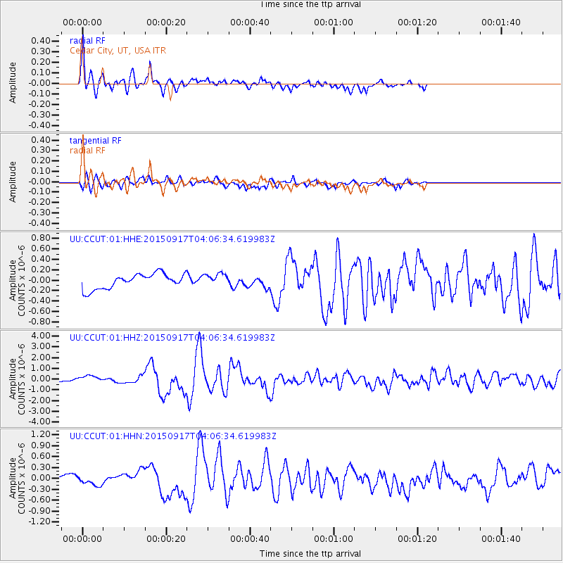
Signal To Noise
| Channel | StoN | STA | LTA |
| UU:CCUT:01:HHZ:20150917T04:06:34.619983Z | 2.8046951 | 3.9679074E-7 | 1.4147375E-7 |
| UU:CCUT:01:HHN:20150917T04:06:34.619983Z | 1.1206721 | 1.1823926E-7 | 1.0550745E-7 |
| UU:CCUT:01:HHE:20150917T04:06:34.619983Z | 0.8366113 | 1.1995282E-7 | 1.4337938E-7 |
| Arrivals |
| Ps | 2.2 SECOND |
| PpPs | 8.6 SECOND |
| PsPs/PpSs | 11 SECOND |


