You are here: Home > Network List > 7A - Mid-Atlantic Geophysical Integrative Collaboration Stations List
> Station INTX Elkton, Virginia USA > Earthquake Result Viewer
INTX Elkton, Virginia USA - Earthquake Result Viewer
| Earthquake location: |
Near Coast Of Northern Chile |
| Earthquake latitude/longitude: |
-26.1/-70.6 |
| Earthquake time(UTC): |
2016/07/25 (207) 17:26:49 GMT |
| Earthquake Depth: |
68 km |
| Earthquake Magnitude: |
6.2 MB |
| Earthquake Catalog/Contributor: |
NEIC PDE/NEIC COMCAT |
|
| Network: |
7A Mid-Atlantic Geophysical Integrative Collaboration |
| Station: |
INTX Elkton, Virginia USA |
| Lat/Lon: |
38.40 N/78.59 W |
| Elevation: |
320 m |
|
| Distance: |
64.6 deg |
| Az: |
353.1 deg |
| Baz: |
172.097 deg |
| Ray Param: |
0.0586549 |
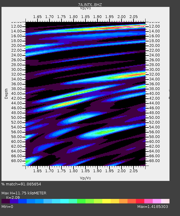
| Estimated Moho Depth: |
11.75 km |
| Estimated Crust Vp/Vs: |
2.09 |
| Assumed Crust Vp: |
6.159 km/s |
| Estimated Crust Vs: |
2.947 km/s |
| Estimated Crust Poisson's Ratio: |
0.35 |
|
| Radial Match: |
91.865654 % |
| Radial Bump: |
400 |
| Transverse Match: |
86.99426 % |
| Transverse Bump: |
400 |
| SOD ConfigId: |
11737051 |
| Insert Time: |
2019-04-25 04:16:37.366 +0000 |
| GWidth: |
2.5 |
| Max Bumps: |
400 |
| Tol: |
0.001 |
|

Signal To Noise
| Channel | StoN | STA | LTA |
| 7A:INTX: :BHZ:20160725T17:36:49.390027Z | 18.40092 | 9.971848E-7 | 5.419211E-8 |
| 7A:INTX: :BHN:20160725T17:36:49.390027Z | 5.781789 | 5.6676606E-7 | 9.8026085E-8 |
| 7A:INTX: :BHE:20160725T17:36:49.390027Z | 1.9628431 | 1.9210295E-7 | 9.7869744E-8 |
| Arrivals |
| Ps | 2.1 SECOND |
| PpPs | 5.7 SECOND |
| PsPs/PpSs | 7.9 SECOND |


