You are here: Home > Network List > US - United States National Seismic Network Stations List
> Station GLMI Grayling, Michigan, USA > Earthquake Result Viewer
GLMI Grayling, Michigan, USA - Earthquake Result Viewer
| Earthquake location: |
Komandorskiye Ostrova Region |
| Earthquake latitude/longitude: |
53.6/169.7 |
| Earthquake time(UTC): |
2007/07/29 (210) 04:54:36 GMT |
| Earthquake Depth: |
26 km |
| Earthquake Magnitude: |
6.0 MB, 5.5 MS, 5.9 MW, 5.8 MW |
| Earthquake Catalog/Contributor: |
WHDF/NEIC |
|
| Network: |
US United States National Seismic Network |
| Station: |
GLMI Grayling, Michigan, USA |
| Lat/Lon: |
44.82 N/84.62 W |
| Elevation: |
387 m |
|
| Distance: |
63.3 deg |
| Az: |
50.102 deg |
| Baz: |
320.066 deg |
| Ray Param: |
0.059655502 |
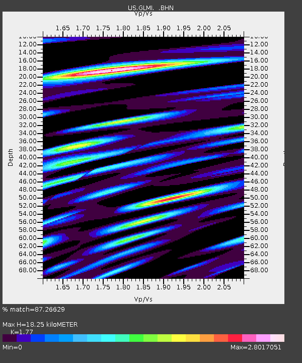
| Estimated Moho Depth: |
18.25 km |
| Estimated Crust Vp/Vs: |
1.77 |
| Assumed Crust Vp: |
6.483 km/s |
| Estimated Crust Vs: |
3.662 km/s |
| Estimated Crust Poisson's Ratio: |
0.27 |
|
| Radial Match: |
87.26629 % |
| Radial Bump: |
400 |
| Transverse Match: |
85.33356 % |
| Transverse Bump: |
400 |
| SOD ConfigId: |
2564 |
| Insert Time: |
2010-03-05 05:42:17.539 +0000 |
| GWidth: |
2.5 |
| Max Bumps: |
400 |
| Tol: |
0.001 |
|

Signal To Noise
| Channel | StoN | STA | LTA |
| US:GLMI: :BHN:20070729T05:04:31.999001Z | 3.3663874 | 8.232887E-7 | 2.4456148E-7 |
| US:GLMI: :BHE:20070729T05:04:31.999001Z | 2.9367325 | 6.9297766E-7 | 2.3596893E-7 |
| US:GLMI: :BHZ:20070729T05:04:31.999001Z | 11.308701 | 1.6536222E-6 | 1.4622567E-7 |
| Arrivals |
| Ps | 2.3 SECOND |
| PpPs | 7.5 SECOND |
| PsPs/PpSs | 9.7 SECOND |


