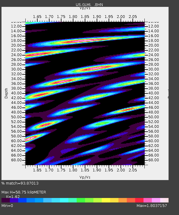
GLMI Grayling, Michigan, USA - Earthquake Result Viewer
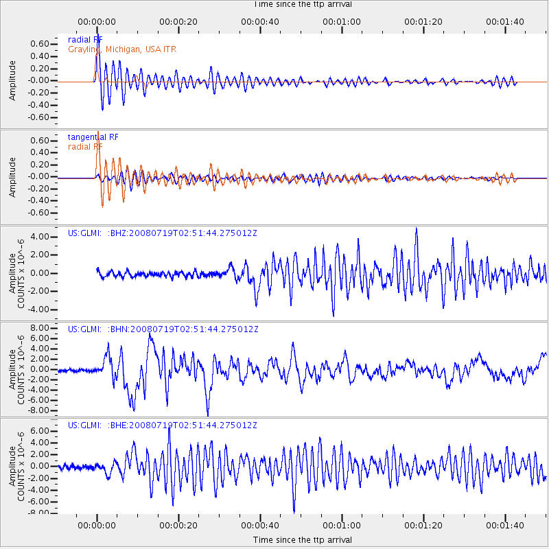
Earthquake location: Off East Coast Of Honshu, Japan
Earthquake latitude/longitude: 37.6/142.2
Earthquake time(UTC): 2008/07/19 (201) 02:39:28 GMT
Earthquake Depth: 22 km
Earthquake Magnitude: 6.2 MB, 7.0 MS, 7.0 MW, 6.9 MW
Earthquake Catalog/Contributor: WHDF/NEIC
Network: US United States National Seismic Network
Station: GLMI Grayling, Michigan, USA
Lat/Lon: 44.82 N/84.62 W
Elevation: 387 m
Distance: 87.7 deg
Az: 31.294 deg
Baz: 324.541 deg
Ray Param: 0.043084417
Estimated Moho Depth: 58.75 km
Estimated Crust Vp/Vs: 1.62
Assumed Crust Vp: 6.483 km/s
Estimated Crust Vs: 4.002 km/s
Estimated Crust Poisson's Ratio: 0.19
Radial Match: 93.87013 %
Radial Bump: 400
Transverse Match: 83.753944 %
Transverse Bump: 400
SOD ConfigId: 2504
Insert Time: 2010-03-05 05:42:36.212 +0000
GWidth: 2.5
Max Bumps: 400
Tol: 0.001

Signal To Noise

ChannelStoNSTALTA
US:GLMI: :BHN:20080719T02:51:44.275012Z14.6150892.0641955E-61.4123728E-7
US:GLMI: :BHE:20080719T02:51:44.275012Z3.88437189.0636473E-72.3333625E-7
US:GLMI: :BHZ:20080719T02:51:44.275012Z2.14993525.480755E-72.549265E-7
Arrivals
Ps5.8 SECOND
PpPs23 SECOND
PsPs/PpSs29 SECOND