You are here: Home > Network List > IM - International Miscellaneous Stations Stations List
> Station TX31 TXAR Array, Lajitas, TX, USA > Earthquake Result Viewer
TX31 TXAR Array, Lajitas, TX, USA - Earthquake Result Viewer
| Earthquake location: |
Near Coast Of Northern Chile |
| Earthquake latitude/longitude: |
-26.1/-70.6 |
| Earthquake time(UTC): |
2016/07/25 (207) 17:26:49 GMT |
| Earthquake Depth: |
68 km |
| Earthquake Magnitude: |
6.2 MB |
| Earthquake Catalog/Contributor: |
NEIC PDE/NEIC COMCAT |
|
| Network: |
IM International Miscellaneous Stations |
| Station: |
TX31 TXAR Array, Lajitas, TX, USA |
| Lat/Lon: |
29.33 N/103.67 W |
| Elevation: |
991 m |
|
| Distance: |
63.6 deg |
| Az: |
327.904 deg |
| Baz: |
146.829 deg |
| Ray Param: |
0.05931798 |
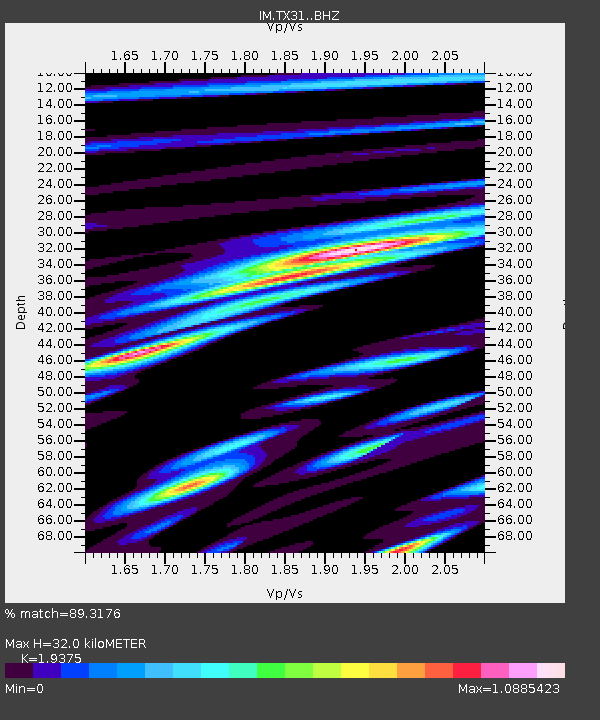
| Estimated Moho Depth: |
32.0 km |
| Estimated Crust Vp/Vs: |
1.94 |
| Assumed Crust Vp: |
6.419 km/s |
| Estimated Crust Vs: |
3.313 km/s |
| Estimated Crust Poisson's Ratio: |
0.32 |
|
| Radial Match: |
89.3176 % |
| Radial Bump: |
400 |
| Transverse Match: |
73.76259 % |
| Transverse Bump: |
400 |
| SOD ConfigId: |
11737051 |
| Insert Time: |
2019-04-25 04:19:56.994 +0000 |
| GWidth: |
2.5 |
| Max Bumps: |
400 |
| Tol: |
0.001 |
|

Signal To Noise
| Channel | StoN | STA | LTA |
| IM:TX31: :BHZ:20160725T17:36:43.023999Z | 12.676849 | 7.252621E-6 | 5.721154E-7 |
| IM:TX31: :BHN:20160725T17:36:43.023999Z | 10.603566 | 3.8232247E-6 | 3.6056025E-7 |
| IM:TX31: :BHE:20160725T17:36:43.023999Z | 8.506876 | 2.8626114E-6 | 3.3650562E-7 |
| Arrivals |
| Ps | 4.9 SECOND |
| PpPs | 14 SECOND |
| PsPs/PpSs | 19 SECOND |


