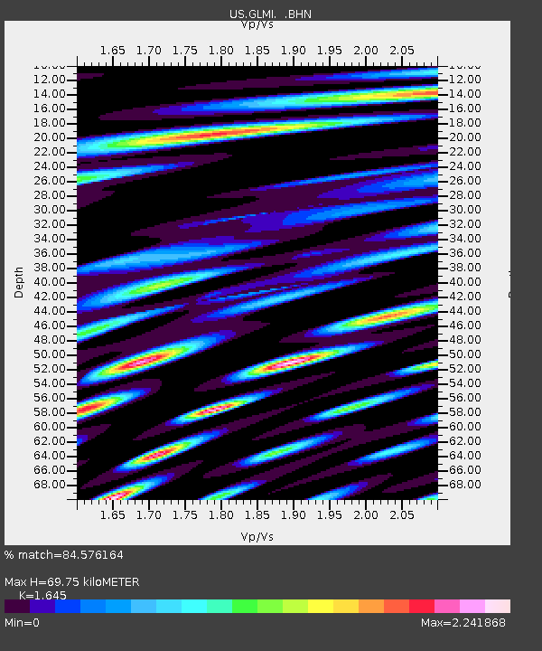
GLMI Grayling, Michigan, USA - Earthquake Result Viewer

Earthquake location: Near Coast Of Chiapas, Mexico
Earthquake latitude/longitude: 14.4/-92.4
Earthquake time(UTC): 2008/10/16 (290) 19:41:25 GMT
Earthquake Depth: 24 km
Earthquake Magnitude: 6.1 MB, 6.6 MS, 6.7 MW, 6.6 MW
Earthquake Catalog/Contributor: WHDF/NEIC
Network: US United States National Seismic Network
Station: GLMI Grayling, Michigan, USA
Lat/Lon: 44.82 N/84.62 W
Elevation: 387 m
Distance: 31.0 deg
Az: 10.731 deg
Baz: 194.685 deg
Ray Param: 0.07916413
Estimated Moho Depth: 69.75 km
Estimated Crust Vp/Vs: 1.64
Assumed Crust Vp: 6.483 km/s
Estimated Crust Vs: 3.941 km/s
Estimated Crust Poisson's Ratio: 0.21
Radial Match: 84.576164 %
Radial Bump: 400
Transverse Match: 63.44401 %
Transverse Bump: 400
SOD ConfigId: 2556
Insert Time: 2010-03-05 05:42:41.114 +0000
GWidth: 2.5
Max Bumps: 400
Tol: 0.001

Signal To Noise

ChannelStoNSTALTA
US:GLMI: :BHN:20081016T19:47:10.773986Z3.64934592.3526777E-66.4468475E-7
US:GLMI: :BHE:20081016T19:47:10.773986Z2.31314421.7300351E-67.4791495E-7
US:GLMI: :BHZ:20081016T19:47:10.773986Z1.61006461.2507842E-67.768534E-7
Arrivals
Ps7.6 SECOND
PpPs26 SECOND
PsPs/PpSs34 SECOND