You are here: Home > Network List > LD - Lamont-Doherty Cooperative Seismographic Network Stations List
> Station HBVT Hinesburg, VT > Earthquake Result Viewer
HBVT Hinesburg, VT - Earthquake Result Viewer
| Earthquake location: |
Near Coast Of Northern Chile |
| Earthquake latitude/longitude: |
-26.1/-70.6 |
| Earthquake time(UTC): |
2016/07/25 (207) 17:26:49 GMT |
| Earthquake Depth: |
68 km |
| Earthquake Magnitude: |
6.2 MB |
| Earthquake Catalog/Contributor: |
NEIC PDE/NEIC COMCAT |
|
| Network: |
LD Lamont-Doherty Cooperative Seismographic Network |
| Station: |
HBVT Hinesburg, VT |
| Lat/Lon: |
44.36 N/73.07 W |
| Elevation: |
1130 m |
|
| Distance: |
70.2 deg |
| Az: |
358.156 deg |
| Baz: |
177.688 deg |
| Ray Param: |
0.055012953 |
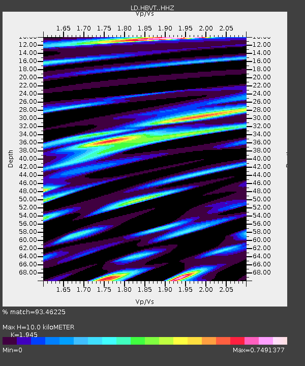
| Estimated Moho Depth: |
10.0 km |
| Estimated Crust Vp/Vs: |
1.95 |
| Assumed Crust Vp: |
6.419 km/s |
| Estimated Crust Vs: |
3.3 km/s |
| Estimated Crust Poisson's Ratio: |
0.32 |
|
| Radial Match: |
93.46225 % |
| Radial Bump: |
266 |
| Transverse Match: |
67.9078 % |
| Transverse Bump: |
354 |
| SOD ConfigId: |
11737051 |
| Insert Time: |
2019-04-25 04:20:15.851 +0000 |
| GWidth: |
2.5 |
| Max Bumps: |
400 |
| Tol: |
0.001 |
|

Signal To Noise
| Channel | StoN | STA | LTA |
| LD:HBVT: :HHZ:20160725T17:37:24.294995Z | 9.139722 | 7.579702E-7 | 8.293143E-8 |
| LD:HBVT: :HHN:20160725T17:37:24.294995Z | 3.2325726 | 2.932748E-7 | 9.0724896E-8 |
| LD:HBVT: :HHE:20160725T17:37:24.294995Z | 0.6690358 | 8.605183E-8 | 1.2862067E-7 |
| Arrivals |
| Ps | 1.5 SECOND |
| PpPs | 4.4 SECOND |
| PsPs/PpSs | 6.0 SECOND |


