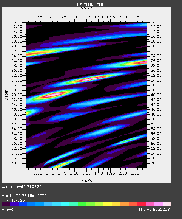
GLMI Grayling, Michigan, USA - Earthquake Result Viewer

Earthquake location: Off Coast Of Jalisco, Mexico
Earthquake latitude/longitude: 17.6/-105.5
Earthquake time(UTC): 2008/09/24 (268) 02:33:05 GMT
Earthquake Depth: 10 km
Earthquake Magnitude: 5.7 MB, 6.2 MS, 6.4 MW, 6.4 MW
Earthquake Catalog/Contributor: WHDF/NEIC
Network: US United States National Seismic Network
Station: GLMI Grayling, Michigan, USA
Lat/Lon: 44.82 N/84.62 W
Elevation: 387 m
Distance: 32.3 deg
Az: 28.348 deg
Baz: 219.522 deg
Ray Param: 0.07871426
Estimated Moho Depth: 39.75 km
Estimated Crust Vp/Vs: 1.71
Assumed Crust Vp: 6.483 km/s
Estimated Crust Vs: 3.785 km/s
Estimated Crust Poisson's Ratio: 0.24
Radial Match: 90.710724 %
Radial Bump: 400
Transverse Match: 68.0292 %
Transverse Bump: 400
SOD ConfigId: 2560
Insert Time: 2010-03-05 05:42:42.776 +0000
GWidth: 2.5
Max Bumps: 400
Tol: 0.001

Signal To Noise

ChannelStoNSTALTA
US:GLMI: :BHN:20080924T02:39:03.398986Z4.5534911.1787604E-62.588696E-7
US:GLMI: :BHE:20080924T02:39:03.398986Z2.29220917.940088E-73.463946E-7
US:GLMI: :BHZ:20080924T02:39:03.398986Z2.98775089.396954E-73.1451597E-7
Arrivals
Ps4.8 SECOND
PpPs15 SECOND
PsPs/PpSs20 SECOND