You are here: Home > Network List > LD - Lamont-Doherty Cooperative Seismographic Network Stations List
> Station WUPA West Chester University of Pennsylvania > Earthquake Result Viewer
WUPA West Chester University of Pennsylvania - Earthquake Result Viewer
| Earthquake location: |
Near Coast Of Northern Chile |
| Earthquake latitude/longitude: |
-26.1/-70.6 |
| Earthquake time(UTC): |
2016/07/25 (207) 17:26:49 GMT |
| Earthquake Depth: |
68 km |
| Earthquake Magnitude: |
6.2 MB |
| Earthquake Catalog/Contributor: |
NEIC PDE/NEIC COMCAT |
|
| Network: |
LD Lamont-Doherty Cooperative Seismographic Network |
| Station: |
WUPA West Chester University of Pennsylvania |
| Lat/Lon: |
39.93 N/75.61 W |
| Elevation: |
86 m |
|
| Distance: |
65.9 deg |
| Az: |
355.822 deg |
| Baz: |
175.113 deg |
| Ray Param: |
0.057832036 |
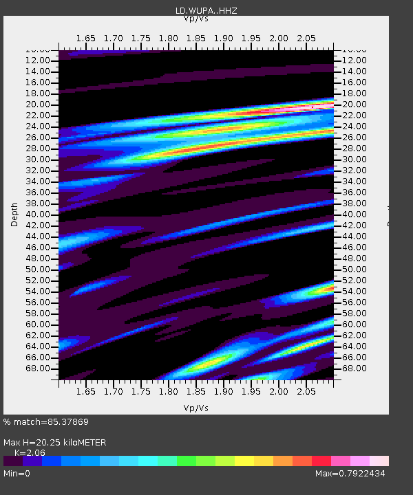
| Estimated Moho Depth: |
20.25 km |
| Estimated Crust Vp/Vs: |
2.06 |
| Assumed Crust Vp: |
6.287 km/s |
| Estimated Crust Vs: |
3.052 km/s |
| Estimated Crust Poisson's Ratio: |
0.35 |
|
| Radial Match: |
85.37869 % |
| Radial Bump: |
283 |
| Transverse Match: |
42.29062 % |
| Transverse Bump: |
400 |
| SOD ConfigId: |
11737051 |
| Insert Time: |
2019-04-25 04:20:33.906 +0000 |
| GWidth: |
2.5 |
| Max Bumps: |
400 |
| Tol: |
0.001 |
|

Signal To Noise
| Channel | StoN | STA | LTA |
| LD:WUPA: :HHZ:20160725T17:36:57.450024Z | 6.305618 | 3.1601127E-7 | 5.0115826E-8 |
| LD:WUPA: :HHN:20160725T17:36:57.450024Z | 2.3387246 | 1.7465351E-7 | 7.467895E-8 |
| LD:WUPA: :HHE:20160725T17:36:57.450024Z | 1.3394957 | 6.436072E-8 | 4.8048474E-8 |
| Arrivals |
| Ps | 3.5 SECOND |
| PpPs | 9.5 SECOND |
| PsPs/PpSs | 13 SECOND |


