GLMI Grayling, Michigan, USA - Earthquake Result Viewer
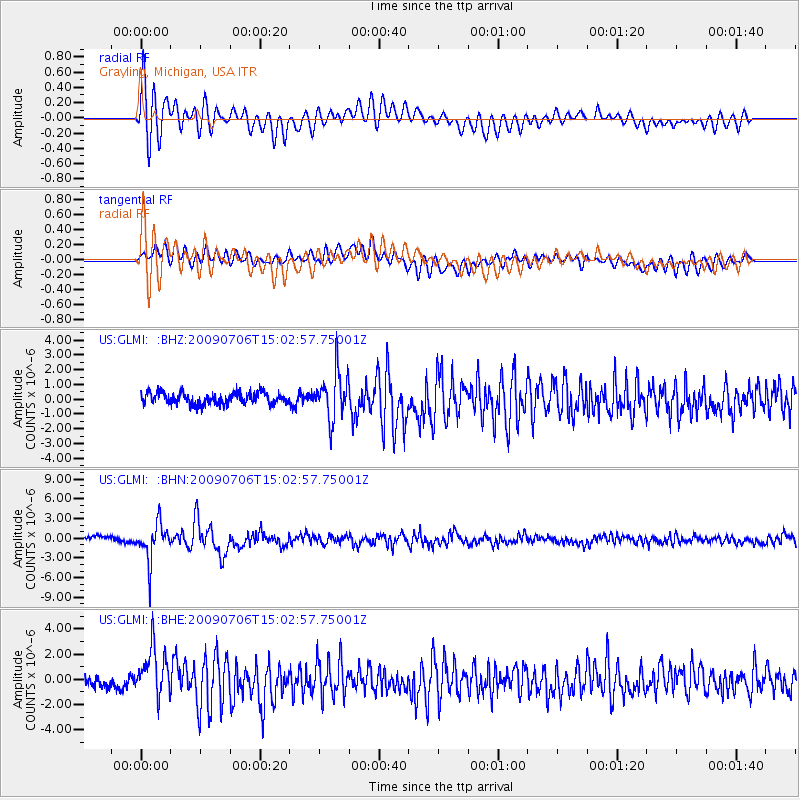
Earthquake location: Rat Islands, Aleutian Islands
Earthquake latitude/longitude: 50.4/177.0
Earthquake time(UTC): 2009/07/06 (187) 14:53:12 GMT
Earthquake Depth: 22 km
Earthquake Magnitude: 6.0 MB, 5.8 MS, 6.1 MW, 6.0 MW
Earthquake Catalog/Contributor: WHDF/NEIC
Network: US United States National Seismic Network
Station: GLMI Grayling, Michigan, USA
Lat/Lon: 44.82 N/84.62 W
Elevation: 387 m
Distance: 61.7 deg
Az: 53.073 deg
Baz: 314.08 deg
Ray Param: 0.06066518
Estimated Moho Depth: 18.75 km
Estimated Crust Vp/Vs: 1.75
Assumed Crust Vp: 6.483 km/s
Estimated Crust Vs: 3.704 km/s
Estimated Crust Poisson's Ratio: 0.26
Radial Match: 84.45225 %
Radial Bump: 400
Transverse Match: 67.420975 %
Transverse Bump: 400
SOD ConfigId: 2648
Insert Time: 2010-03-05 05:42:58.905 +0000
GWidth: 2.5
Max Bumps: 400
Tol: 0.001

Signal To Noise

ChannelStoNSTALTA
US:GLMI: :BHN:20090706T15:02:57.75001Z5.5641052.8326654E-65.090963E-7
US:GLMI: :BHE:20090706T15:02:57.75001Z4.47705751.9302556E-64.3114383E-7
US:GLMI: :BHZ:20090706T15:02:57.75001Z4.03075931.5738675E-63.904643E-7
Arrivals
Ps2.3 SECOND
PpPs7.6 SECOND
PsPs/PpSs9.9 SECOND