You are here: Home > Network List > US - United States National Seismic Network Stations List
> Station GLMI Grayling, Michigan, USA > Earthquake Result Viewer
GLMI Grayling, Michigan, USA - Earthquake Result Viewer
| Earthquake location: |
Santiago Del Estero Prov., Arg. |
| Earthquake latitude/longitude: |
-26.9/-63.1 |
| Earthquake time(UTC): |
2006/09/22 (265) 02:32:25 GMT |
| Earthquake Depth: |
598 km |
| Earthquake Magnitude: |
6.1 MB, 6.0 MW, 6.0 MW |
| Earthquake Catalog/Contributor: |
WHDF/NEIC |
|
| Network: |
US United States National Seismic Network |
| Station: |
GLMI Grayling, Michigan, USA |
| Lat/Lon: |
44.82 N/84.62 W |
| Elevation: |
387 m |
|
| Distance: |
74.0 deg |
| Az: |
344.279 deg |
| Baz: |
160.116 deg |
| Ray Param: |
0.05064974 |
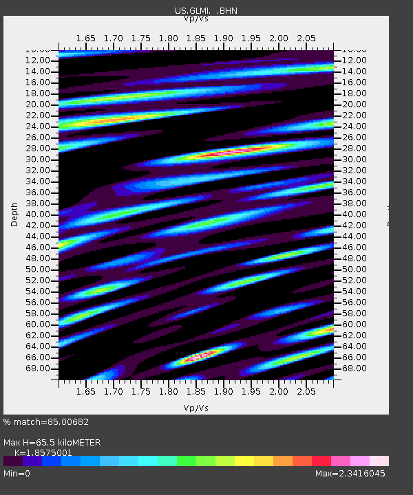
| Estimated Moho Depth: |
65.5 km |
| Estimated Crust Vp/Vs: |
1.86 |
| Assumed Crust Vp: |
6.483 km/s |
| Estimated Crust Vs: |
3.49 km/s |
| Estimated Crust Poisson's Ratio: |
0.30 |
|
| Radial Match: |
85.00682 % |
| Radial Bump: |
375 |
| Transverse Match: |
73.56981 % |
| Transverse Bump: |
400 |
| SOD ConfigId: |
2665 |
| Insert Time: |
2010-03-05 05:43:11.205 +0000 |
| GWidth: |
2.5 |
| Max Bumps: |
400 |
| Tol: |
0.001 |
|

Signal To Noise
| Channel | StoN | STA | LTA |
| US:GLMI: :BHN:20060922T02:42:30.29802Z | 6.823217 | 2.8775523E-6 | 4.2172957E-7 |
| US:GLMI: :BHE:20060922T02:42:30.29802Z | 5.2803683 | 2.1867143E-6 | 4.1412156E-7 |
| US:GLMI: :BHZ:20060922T02:42:30.29802Z | 14.267208 | 5.7463794E-6 | 4.0276834E-7 |
| Arrivals |
| Ps | 8.9 SECOND |
| PpPs | 28 SECOND |
| PsPs/PpSs | 37 SECOND |


