You are here: Home > Network List > US - United States National Seismic Network Stations List
> Station GLMI Grayling, Michigan, USA > Earthquake Result Viewer
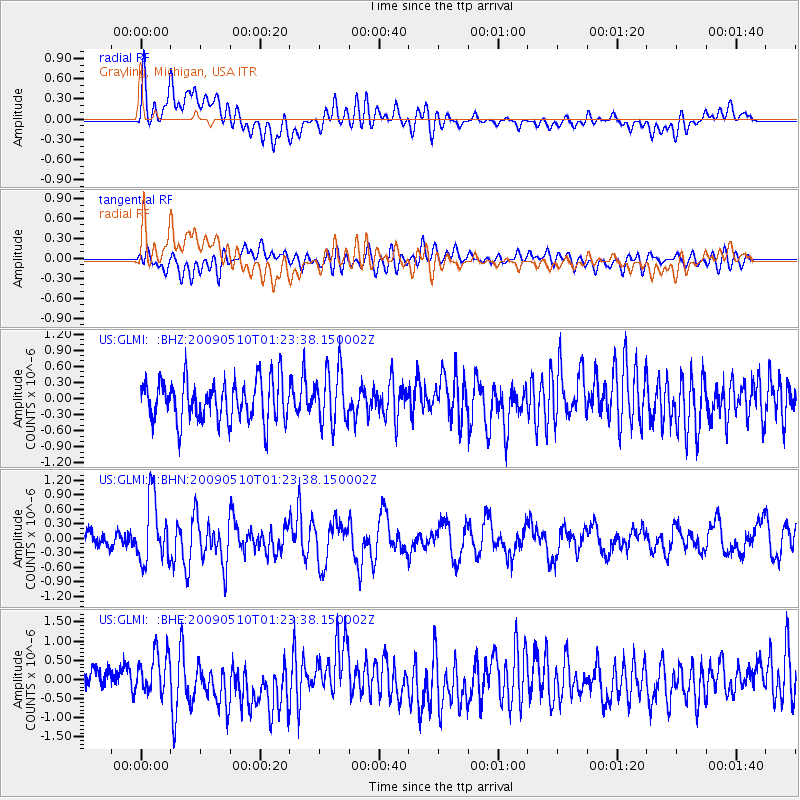
GLMI Grayling, Michigan, USA - Earthquake Result Viewer
*The percent match for this event was below the threshold and hence no stack was calculated.
| Earthquake location: |
Off Coast Of Ecuador |
| Earthquake latitude/longitude: |
1.4/-85.2 |
| Earthquake time(UTC): |
2009/05/10 (130) 01:16:06 GMT |
| Earthquake Depth: |
6.0 km |
| Earthquake Magnitude: |
5.5 MB, 5.7 MS, 6.1 MW, 6.1 MW |
| Earthquake Catalog/Contributor: |
WHDF/NEIC |
|
| Network: |
US United States National Seismic Network |
| Station: |
GLMI Grayling, Michigan, USA |
| Lat/Lon: |
44.82 N/84.62 W |
| Elevation: |
387 m |
|
| Distance: |
43.3 deg |
| Az: |
0.573 deg |
| Baz: |
180.805 deg |
| Ray Param: |
$rayparam |
*The percent match for this event was below the threshold and hence was not used in the summary stack. |
|
| Radial Match: |
64.038246 % |
| Radial Bump: |
400 |
| Transverse Match: |
51.14678 % |
| Transverse Bump: |
400 |
| SOD ConfigId: |
2760 |
| Insert Time: |
2010-03-05 05:43:16.113 +0000 |
| GWidth: |
2.5 |
| Max Bumps: |
400 |
| Tol: |
0.001 |
|
Signal To Noise
| Channel | StoN | STA | LTA |
| US:GLMI: :BHN:20090510T01:23:38.150002Z | 3.8561645 | 6.5417055E-7 | 1.696428E-7 |
| US:GLMI: :BHE:20090510T01:23:38.150002Z | 1.7237519 | 5.280517E-7 | 3.0633856E-7 |
| US:GLMI: :BHZ:20090510T01:23:38.150002Z | 1.296465 | 4.9340684E-7 | 3.805786E-7 |
| Arrivals |
| Ps | |
| PpPs | |
| PsPs/PpSs | |


