You are here: Home > Network List > US - United States National Seismic Network Stations List
> Station GLMI Grayling, Michigan, USA > Earthquake Result Viewer
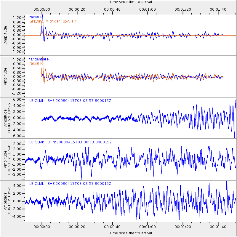
GLMI Grayling, Michigan, USA - Earthquake Result Viewer
*The percent match for this event was below the threshold and hence no stack was calculated.
| Earthquake location: |
Near Coast Of Guatemala |
| Earthquake latitude/longitude: |
13.6/-90.6 |
| Earthquake time(UTC): |
2008/04/15 (106) 03:03:04 GMT |
| Earthquake Depth: |
33 km |
| Earthquake Magnitude: |
5.6 MB, 5.8 MS, 6.1 MW, 6.1 MW |
| Earthquake Catalog/Contributor: |
WHDF/NEIC |
|
| Network: |
US United States National Seismic Network |
| Station: |
GLMI Grayling, Michigan, USA |
| Lat/Lon: |
44.82 N/84.62 W |
| Elevation: |
387 m |
|
| Distance: |
31.6 deg |
| Az: |
8.143 deg |
| Baz: |
191.161 deg |
| Ray Param: |
$rayparam |
*The percent match for this event was below the threshold and hence was not used in the summary stack. |
|
| Radial Match: |
78.14522 % |
| Radial Bump: |
400 |
| Transverse Match: |
64.63414 % |
| Transverse Bump: |
400 |
| SOD ConfigId: |
2504 |
| Insert Time: |
2010-03-05 05:43:18.984 +0000 |
| GWidth: |
2.5 |
| Max Bumps: |
400 |
| Tol: |
0.001 |
|
Signal To Noise
| Channel | StoN | STA | LTA |
| US:GLMI: :BHN:20080415T03:08:53.800015Z | 3.0518816 | 8.931544E-7 | 2.9265698E-7 |
| US:GLMI: :BHE:20080415T03:08:53.800015Z | 1.8531029 | 8.876776E-7 | 4.790223E-7 |
| US:GLMI: :BHZ:20080415T03:08:53.800015Z | 0.74610966 | 2.9564444E-7 | 3.9624797E-7 |
| Arrivals |
| Ps | |
| PpPs | |
| PsPs/PpSs | |


