You are here: Home > Network List > CU - Caribbean Network (USGS) Stations List
> Station SDDR Presa de Sabaneta, Dominican Republic > Earthquake Result Viewer
SDDR Presa de Sabaneta, Dominican Republic - Earthquake Result Viewer
| Earthquake location: |
Near Coast Of Central Chile |
| Earthquake latitude/longitude: |
-31.5/-71.8 |
| Earthquake time(UTC): |
2015/09/17 (260) 04:10:31 GMT |
| Earthquake Depth: |
40 km |
| Earthquake Magnitude: |
6.3 MB |
| Earthquake Catalog/Contributor: |
NEIC PDE/NEIC COMCAT |
|
| Network: |
CU Caribbean Network (USGS) |
| Station: |
SDDR Presa de Sabaneta, Dominican Republic |
| Lat/Lon: |
18.98 N/71.29 W |
| Elevation: |
589 m |
|
| Distance: |
50.2 deg |
| Az: |
0.595 deg |
| Baz: |
180.537 deg |
| Ray Param: |
0.06810921 |
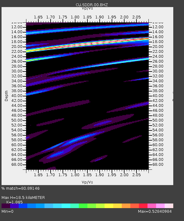
| Estimated Moho Depth: |
18.5 km |
| Estimated Crust Vp/Vs: |
1.87 |
| Assumed Crust Vp: |
6.448 km/s |
| Estimated Crust Vs: |
3.457 km/s |
| Estimated Crust Poisson's Ratio: |
0.30 |
|
| Radial Match: |
80.89146 % |
| Radial Bump: |
400 |
| Transverse Match: |
55.85256 % |
| Transverse Bump: |
400 |
| SOD ConfigId: |
1156111 |
| Insert Time: |
2015-10-01 04:31:02.815 +0000 |
| GWidth: |
2.5 |
| Max Bumps: |
400 |
| Tol: |
0.001 |
|

Signal To Noise
| Channel | StoN | STA | LTA |
| CU:SDDR:00:BHZ:20150917T04:18:52.449005Z | 3.534621 | 3.821557E-6 | 1.0811788E-6 |
| CU:SDDR:00:BH1:20150917T04:18:52.449005Z | 1.9088316 | 1.4658619E-6 | 7.6793674E-7 |
| CU:SDDR:00:BH2:20150917T04:18:52.449005Z | 0.7022717 | 7.9849775E-7 | 1.1370211E-6 |
| Arrivals |
| Ps | 2.6 SECOND |
| PpPs | 7.8 SECOND |
| PsPs/PpSs | 10 SECOND |


